File:Rete autostradale italiana.svg

Size of this PNG preview of this SVG file: 418 × 494 pixels. Other resolutions: 203 × 240 pixels | 406 × 480 pixels | 650 × 768 pixels | 866 × 1,024 pixels | 1,733 × 2,048 pixels.
Original file (SVG file, nominally 418 × 494 pixels, file size: 49 KB)
Captions
Captions
Add a one-line explanation of what this file represents
| Description |
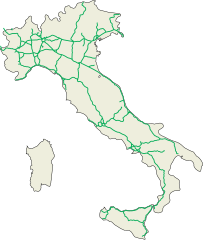
English: Italian motorway network (motorways, distributions, connections, orbitals).
Español: Red de autopistas italianas (carreteras, distribuciones, conexiones, circunvalaciónes).
Italiano: Rete autostradale italiana (autostrade, diramazioni autostradali, raccordi autostradali (compresi quelli classificati con la sigla RA e classificati come autostrada), tangenziali autostradali, trafori alpini internazionali). |
| Date | |
| Source |
English: Own work.
Español: Mi propio trabajo.
Italiano: Fatta da me. |
| Author | ColdShine |
| Permission (Reusing this file) |
This file is licensed under the Creative Commons Attribution-Share Alike 2.5 Generic license.
|
| Other versions | Derivative works of this file: Rete autostradale italiana-labeled.svg |
This W3C-unspecified vector image was created with Inkscape .
| Annotations | This image is annotated: View the annotations at Commons |
File history
Click on a date/time to view the file as it appeared at that time.
| Date/Time | Thumbnail | Dimensions | User | Comment | |
|---|---|---|---|---|---|
| current | 16:36, 11 February 2015 | | 418 × 494 (49 KB) | Gigillo83 (talk | contribs) | Ops... dimenticato di aggiornare... |
| 15:35, 11 February 2015 |  | 418 × 494 (39 KB) | Gigillo83 (talk | contribs) | + A34, A35, A36 and A60 | |
| 10:14, 27 December 2012 |  | 425 × 500 (52 KB) | Gigillo83 (talk | contribs) | Fix A18 | |
| 13:49, 23 October 2010 |  | 425 × 500 (52 KB) | Gigillo83 (talk | contribs) | Finishing A28 | |
| 17:02, 26 January 2010 |  | 425 × 500 (50 KB) | Gigillo83 (talk | contribs) | Aggiunti RA | |
| 20:47, 15 December 2009 |  | 425 × 500 (50 KB) | Gigillo83 (talk | contribs) | Added A33, T2 and the new CT-SR motorway | |
| 08:18, 25 August 2009 |  | 425 × 500 (27 KB) | Xander89 (talk | contribs) | little corrections (T1, T4 added, some minor RA removed) | |
| 18:34, 9 July 2009 |  | 425 × 500 (27 KB) | Xander89 (talk | contribs) | forgotten a ra. | |
| 11:14, 9 July 2009 |  | 425 × 500 (27 KB) | Xander89 (talk | contribs) | RA removed from the map: they are not part of the "Autostrade" system | |
| 13:44, 25 June 2009 |  | 425 × 500 (31 KB) | Xander89 (talk | contribs) | added Mestre's ''Passante'' |
You cannot overwrite this file.
File usage on Commons
The following 5 pages use this file:
File usage on other wikis
The following other wikis use this file:
- Usage on it.wikipedia.org
- Discussioni utente:Lucaf1
- Progetto:Laboratorio grafico/Immagini da migliorare/Archivio risolte/17
- Utente:IlCerretese/Italia
- Progetto:Laboratorio grafico/Immagini da migliorare/Archivio risolte/23
- Progetto:Laboratorio grafico/Immagini da migliorare/Archivio risolte/35
- Progetto:Laboratorio grafico/Immagini da migliorare/Archivio risolte/36
- Progetto:Laboratorio grafico/Immagini da migliorare/Archivio risolte/66
- Utente:T,C&S/Sandbox
- Progetto:Laboratorio grafico/Immagini da migliorare/Archivio risolte/174
- Usage on pl.wikipedia.org