File:Rete tranviaria di Rio de Janeiro.png

Size of this preview: 800 × 590 pixels. Other resolutions: 320 × 236 pixels | 640 × 472 pixels | 1,024 × 755 pixels | 1,280 × 944 pixels | 1,760 × 1,298 pixels.
Original file (1,760 × 1,298 pixels, file size: 2.69 MB, MIME type: image/png)
Captions
Captions
Add a one-line explanation of what this file represents
Summary
edit
| Description |
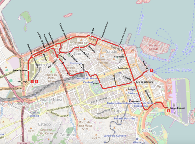
Italiano: Mappa della rete tranviaria di Rio de Janeiro
English: Rio de Janeiro VTL map |
| Date | |
| Source | Own work, Background map from Openstreetmap (http://www.openstreetmap.org) |
| Author | L9A8M |
| Permission (Reusing this file) |
CC-BY-4.0. |
Licensing
edit
This file is licensed under the Creative Commons Attribution 4.0 International license.
- You are free:
- to share – to copy, distribute and transmit the work
- to remix – to adapt the work
- Under the following conditions:
- attribution – You must give appropriate credit, provide a link to the license, and indicate if changes were made. You may do so in any reasonable manner, but not in any way that suggests the licensor endorses you or your use.
Original upload log
edit
The original description page was here. All following user names refer to it.wikipedia.
| Date/Time | Dimensions | User | Comment |
|---|---|---|---|
| 2016-08-02 14:38 | 1760×1298× (2824281 bytes) | L9A8M | {{Informazioni file |Descrizione = Mappa della rete tranviaria di Rio de Janeiro. |Fonte = Opera propria, mappa da Openstreetmap ([http://www.openstreetmap.org/#map=0/-90/-130 http://www.openstreetmap.org]) |Data = 2 agosto 2016 |Autore = [[Utente:L9A8... |
File history
Click on a date/time to view the file as it appeared at that time.
| Date/Time | Thumbnail | Dimensions | User | Comment | |
|---|---|---|---|---|---|
| current | 14:36, 20 May 2017 | | 1,760 × 1,298 (2.69 MB) | L9A8M (talk | contribs) | == {{int:filedesc}} == {{Information |Description={{it|Mappa della rete tranviaria di Rio de Janeiro}} {{en|Rio de Janeiro VTL map}} |Source={{own}}, Background map from Openstreetmap ([http://www.openstreetmap.org/#map=0/-90/-130 http://www.openstreet... |
You cannot overwrite this file.
File usage on Commons
There are no pages that use this file.
File usage on other wikis
The following other wikis use this file:
- Usage on it.wikipedia.org