File:Rheiderland de.png

Size of this preview: 710 × 600 pixels. Other resolutions: 284 × 240 pixels | 568 × 480 pixels | 1,000 × 845 pixels.
Original file (1,000 × 845 pixels, file size: 366 KB, MIME type: image/png)
Captions
Captions
Add a one-line explanation of what this file represents
| Description |
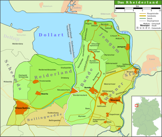
Deutsch: Karte der Region Rheiderland/Reiderland im Nordwesten Deutschlands/Nordosten der Niederlande
English: Map of the region Rheiderland/Reiderland in the north west of Germany/north east of the Netherlands
Plattdüütsch: Kaart van de Region Rheiderland in Noordwest van Düütschland/Noordoost van de Nedderlannen (Schriften hoochdüütsch) |
||
| Date | |||
| Source | own work (based on several atlases and [1]) | ||
| Author | Onno Gabriel | ||
| Permission (Reusing this file) |
I, the copyright holder of this work, hereby publish it under the following licenses:
This file is licensed under the Creative Commons Attribution 3.0 Unported license.
You may select the license of your choice. |
||
| Other versions | The map is not correct, because it considers the villages Scheemda, MIdwolda en Oostwold to the old district Reiderland, but omits Heiligerlee and Westerlee. |

File history
Click on a date/time to view the file as it appeared at that time.
| Date/Time | Thumbnail | Dimensions | User | Comment | |
|---|---|---|---|---|---|
| current | 13:06, 26 August 2007 | | 1,000 × 845 (366 KB) | Onno~commonswiki (talk | contribs) | {{Information |Description = {{de|Karte der Region Rheiderland/Reiderland im Nordwesten Deutschlands/Nordosten der Niederlande}} {{en|Map of the region Rheiderland/Reiderland in the north west of Germany/north east of the Netherlands}} {{nds|Kaart van de |
| 15:27, 25 August 2007 |  | 1,000 × 845 (345 KB) | Onno~commonswiki (talk | contribs) | {{Information |Description = {{de|Map of the region Rheiderland/Reiderland in the north west of Germany/north east of the Netherlands}} {{en|Karte der Region Rheiderland/Reiderland im Nordwesten Deutschlands/Nordosten der Niederlande}} |Source = own work |
You cannot overwrite this file.
File usage on Commons
The following 3 pages use this file:
File usage on other wikis
The following other wikis use this file:
- Usage on azb.wikipedia.org
- Usage on da.wikipedia.org
- Usage on de.wikipedia.org
- Pogum
- Bunde
- Boen
- Rheiderland
- Jemgum
- Midlum (Rheiderland)
- Critzum
- Ditzum
- Holtgaste
- Benutzer:Onno
- Bunderhee
- Stapelmoor
- Kirchborgum
- Nendorp
- Wymeer
- Ditzumerverlaat
- Marienchor
- Weener
- Wikipedia:WikiProjekt Ostfriesland/Kartenzimmer
- Möhlenwarf
- Hatzum
- Landschaftspolder
- Beschotenweg
- Diele (Weener)
- St. Georgiwold
- Weenermoor
- Dollart (Bunde)
- Dielerheide
- Halte
- Holthusen (Weener)
- Holthuserheide
- Stapelmoorerheide
- Tichelwarf
- Heinitzpolder
- Kanalpolder
- Böhmerwold
- Oldendorp
- Wikipedia:Kartenwerkstatt/Archiv/2011-10
- Bunderhammrich
- Ditzumerhammrich
- Vellage
- Benutzer:Aeroid/List DE NI Dorf
- Usage on eo.wikipedia.org
- Usage on fy.wikipedia.org
View more global usage of this file.