File:Ridges in Lycus Sulci (PIA25950).tiff

Original file (2,880 × 1,800 pixels, file size: 7.89 MB, MIME type: image/tiff)
Captions
Captions
Summary
edit| Description |
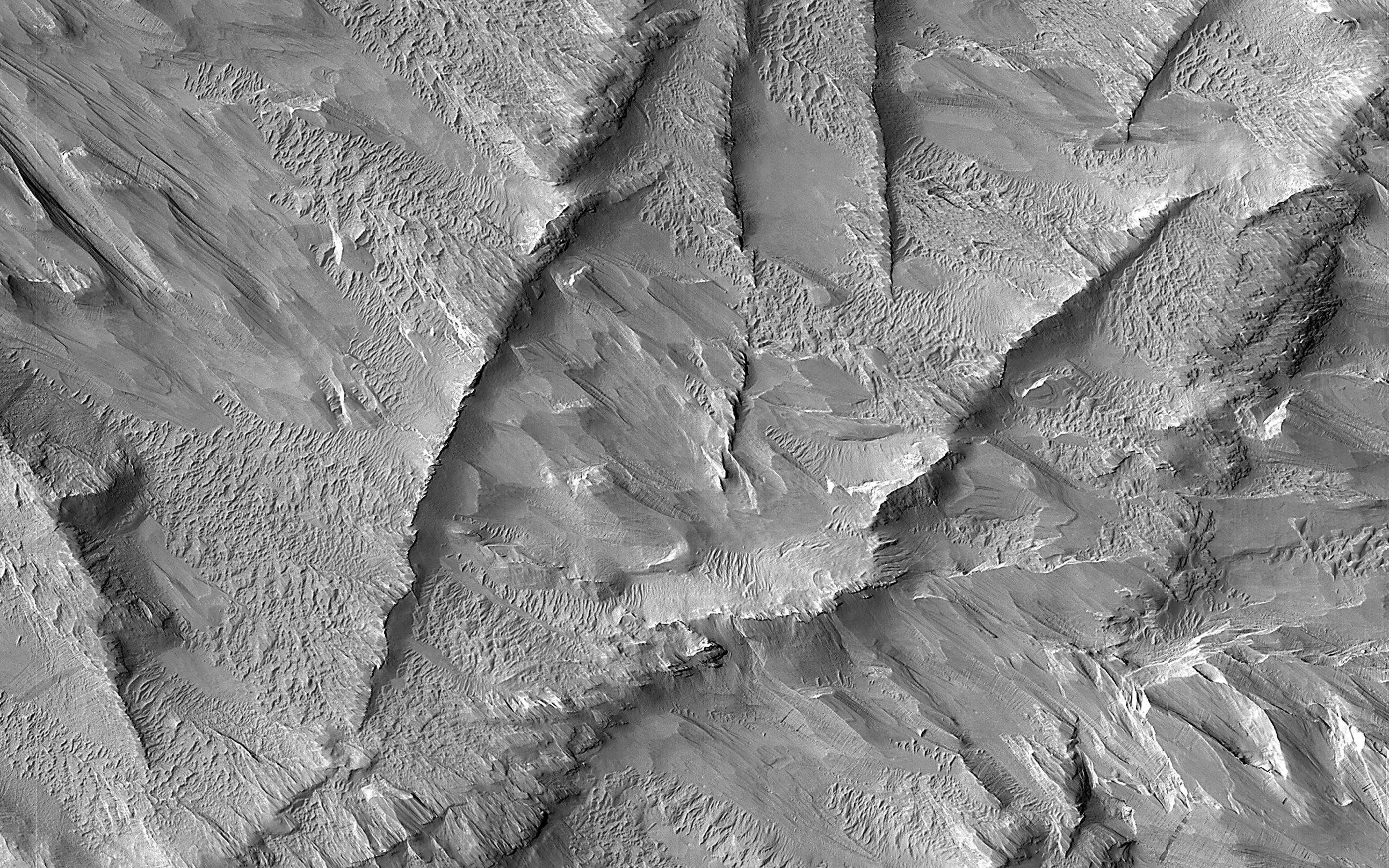
English: .jpg) Map Projected Browse Image Click on image for larger version This image shows a group of curved ridges in an area called Lycus Sulci, which is located near the Olympus Mons volcano. Much of the rocks in this area have been subjected to erosion (e.g., scouring and removal) by the wind, so that the surface we see today was originally buried deep underground. Ridges such like these typically form underground through diagenesis, a process where water flows underground and minerals start to form from chemicals within the groundwater. These minerals are typically most abundant in places such as cracks, where the water can easily flow and minerals have room to grow. The mineral-filled cracks are more difficult to erode than the surrounding rocks and thus can form ridges such like these when the weaker surrounding rocks are eroded away. The map is projected here at a scale of 50 centimeters (19.7 inches) per pixel. (The original image scale is 55.9 centimeters [22.0 inches] per pixel [with 2 x 2 binning]; objects on the order of 168 centimeters [66.1 inches] across are resolved.) North is up. The University of Arizona, in Tucson, operates HiRISE, which was built by Ball Aerospace & Technologies Corp., in Boulder, Colorado. NASA's Jet Propulsion Laboratory, a division of Caltech in Pasadena, California, manages the Mars Reconnaissance Orbiter Project for NASA's Science Mission Directorate, Washington. |
| Date | (published) |
| Source | Catalog page · Full-res (JPEG · TIFF) · Full-res ([ MP4]) · Full-res ([ GIF]) |
| Author | NASA/JPL-Caltech/University of Arizona |
| Other versions |
|
.jpg)
This image or video was catalogued by Jet Propulsion Laboratory of the United States National Aeronautics and Space Administration (NASA) under Photo ID: PIA25950. This tag does not indicate the copyright status of the attached work. A normal copyright tag is still required. See Commons:Licensing. Other languages:
|
| This media is a product of the Mars Reconnaissance Orbiter (MRO) Credit and attribution belongs to the mission team, if not already specified in the "author" row |
Licensing
edit
|
The copyright holder of this file, NASA/JPL-Caltech, allows anyone to use it for any purpose, provided that the copyright holder is properly attributed. Redistribution, derivative work, commercial use, and all other use is permitted. |
|
|
| According to JPL's image use policy additional restriction is that no endorsement of any product or service by Caltech, JPL or NASA is claimed or implied.
Caltech's disclaimer: Caltech makes no representations or warranties with respect to ownership of copyrights in the images, and does not represent others who may claim to be authors or owners of copyright of any of the images, and makes no warranties as to the quality of the images. Caltech shall not be responsible for any loss or expenses resulting from the use of the images, and you release and hold Caltech harmless from all liability arising from such use. Usage on the English Wikipedia: On the English Wikipedia you can use the {{JPL Image}} template to display the copyright notice. (See w:Wikipedia:Using JPL images for details) |
File history
Click on a date/time to view the file as it appeared at that time.
| Date/Time | Thumbnail | Dimensions | User | Comment | |
|---|---|---|---|---|---|
| current | 23:08, 4 July 2023 |  | 2,880 × 1,800 (7.89 MB) | OptimusPrimeBot (talk | contribs) | #Spacemedia - Upload of https://photojournal.jpl.nasa.gov/tiff/PIA25950.tif via Commons:Spacemedia |
You cannot overwrite this file.
File usage on Commons
The following 2 pages use this file: