File:Riesblick1.JPG

Size of this preview: 800 × 600 pixels. Other resolutions: 320 × 240 pixels | 640 × 480 pixels | 1,024 × 768 pixels | 1,280 × 960 pixels | 2,560 × 1,920 pixels | 2,816 × 2,112 pixels.
Original file (2,816 × 2,112 pixels, file size: 2.12 MB, MIME type: image/jpeg)
Captions
Captions
Add a one-line explanation of what this file represents
Summary edit
| Description |
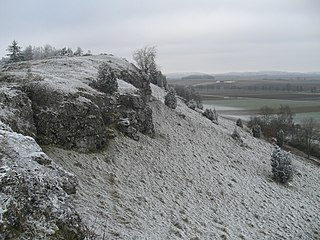
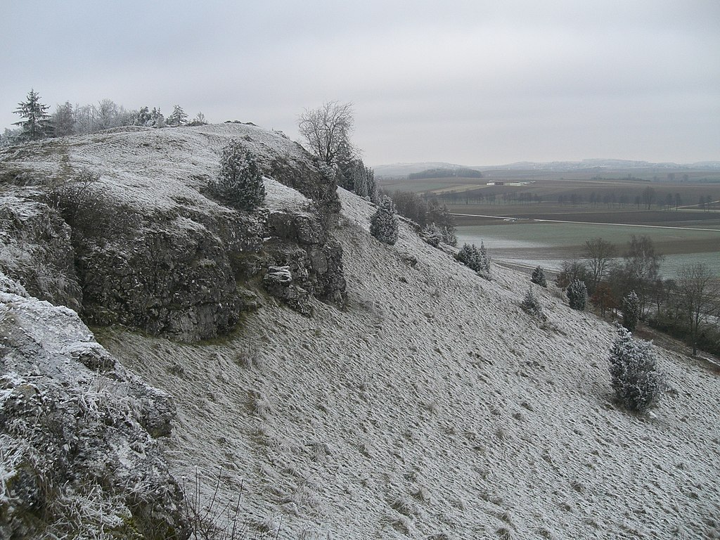
English: Nördlinger Ries, view of the southern crater rim near the village of Mönchsdeggingen. Shattered limestone blocks mark the crater rim on the left, and the flat crater floor is visible in the background at right.
Deutsch: Nördlinger Ries, südlicher Kraterrand bei Mönchsdeggingen. Links markieren zertrümmerte Kalksteinblöcke den Kraterrand, der flache Kraterboden ist rechts im Hintergrund erkennbar. |
| Date | |
| Source | Own work |
| Author | Bernhard Hampp |
| Other versions |
|


Licensing edit
I, the copyright holder of this work, hereby publish it under the following licenses:

|
Permission is granted to copy, distribute and/or modify this document under the terms of the GNU Free Documentation License, Version 1.2 or any later version published by the Free Software Foundation; with no Invariant Sections, no Front-Cover Texts, and no Back-Cover Texts. A copy of the license is included in the section entitled GNU Free Documentation License. |
This file is licensed under the Creative Commons Attribution-Share Alike 3.0 Unported, 2.5 Generic, 2.0 Generic and 1.0 Generic license.
- You are free:
- to share – to copy, distribute and transmit the work
- to remix – to adapt the work
- Under the following conditions:
- attribution – You must give appropriate credit, provide a link to the license, and indicate if changes were made. You may do so in any reasonable manner, but not in any way that suggests the licensor endorses you or your use.
- share alike – If you remix, transform, or build upon the material, you must distribute your contributions under the same or compatible license as the original.
You may select the license of your choice.
| Camera location | | View this and other nearby images on: OpenStreetMap |
|---|
File history
Click on a date/time to view the file as it appeared at that time.
| Date/Time | Thumbnail | Dimensions | User | Comment | |
|---|---|---|---|---|---|
| current | 11:02, 27 December 2007 | | 2,816 × 2,112 (2.12 MB) | Hampp (talk | contribs) | {{Information |Description={{en| Nördlinger Ries, view of the southern crater rim near the village of Mönchsdeggingen. Shattered limestone blocks mark the crater rim on the left, and the flat crater floor is visible in the background at right. }} {{de| |
You cannot overwrite this file.
File usage on Commons
The following 3 pages use this file:
File usage on other wikis
The following other wikis use this file:
- Usage on cs.wikipedia.org
- Usage on de.wikipedia.org
- Usage on fi.wikipedia.org
- Usage on hu.wikipedia.org
- Usage on ro.wikipedia.org