File:Risletal.jpg

Size of this preview: 800 × 267 pixels. Other resolutions: 320 × 107 pixels | 640 × 213 pixels | 1,024 × 341 pixels | 1,280 × 427 pixels | 5,307 × 1,769 pixels.
Original file (5,307 × 1,769 pixels, file size: 5.44 MB, MIME type: image/jpeg)
Captions
Captions
Add a one-line explanation of what this file represents
Summary
edit
| Description |
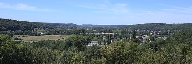
English: Valley of the Risle seen from the medieval castle in Montfort-sur-Risle. In the distance you can see Appeville-Annebault and Condé-sur-Risle. |
| Date | |
| Source | Own work |
| Author | Stanzilla |
| Camera location | | View this and other nearby images on: OpenStreetMap |
|---|
Licensing
edit
I, the copyright holder of this work, hereby publish it under the following license:
This file is licensed under the Creative Commons Attribution-Share Alike 4.0 International license.
- You are free:
- to share – to copy, distribute and transmit the work
- to remix – to adapt the work
- Under the following conditions:
- attribution – You must give appropriate credit, provide a link to the license, and indicate if changes were made. You may do so in any reasonable manner, but not in any way that suggests the licensor endorses you or your use.
- share alike – If you remix, transform, or build upon the material, you must distribute your contributions under the same or compatible license as the original.
File history
Click on a date/time to view the file as it appeared at that time.
| Date/Time | Thumbnail | Dimensions | User | Comment | |
|---|---|---|---|---|---|
| current | 23:19, 5 September 2020 | 5,307 × 1,769 (5.44 MB) | Stanzilla (talk | contribs) | {{Information |description ={{en|1=Valley of the Risle seen from the medieval castle in Montfort-sur-Risle. In the distance you can see Appeville-Annebault and Condé-sur-Risle.}} |date =2020-07-22 |source ={{own}} |author =User:Stanzilla }} Category:Files by User:Stanzilla Category:Montfort-sur-Risle Category:Panoramics in Eure Category:Panoramics of rural areas in France Category:Panoramics of landscapes |
You cannot overwrite this file.
File usage on Commons
The following page uses this file:
- File:Valley of the Risle (50309750706).jpg (file redirect)
.jpg&redirect=no)