File:River Bank Steel Loops - geograph.org.uk - 736951.jpg
No higher resolution available.
River_Bank_Steel_Loops_-_geograph.org.uk_-_736951.jpg (640 × 480 pixels, file size: 97 KB, MIME type: image/jpeg)
Captions
Captions
Add a one-line explanation of what this file represents
Summary
edit
| Description |
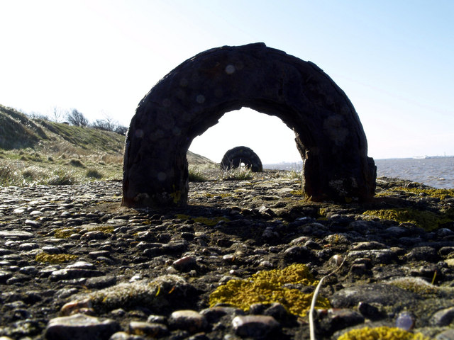
English: River Bank Steel Loops, Paull, East Riding of Yorkshire, England. These loops can be seen in proper context in previous photographs; they're probably only 15cm (6") high! I don't know what their original purpose was - it seems unlikely that they were used for securing boats to as the river level varies too much with the tide and the currents at this point can be very strong too. Their presence at the moment just serves as a dangerous trip hazard for walkers right next to the water's edge! P.S. further investigation shows that the loops were probably the bottom of an iron fence which could have been removed for "the War Effort". Anybody out there able to enlighten me further?! |
| Date | |
| Source | From geograph.org.uk |
| Author | Andy Beecroft |
| Permission (Reusing this file) |
Creative Commons Attribution Share-alike license 2.0 |
| Attribution (required by the license) | Andy Beecroft / River Bank Steel Loops / |
| Camera location | | View this and other nearby images on: OpenStreetMap |
|---|
_heading:157.00&language=en)
| Object location | | View this and other nearby images on: OpenStreetMap |
|---|
_heading:157.00&language=en)
Licensing
edit

|
This image was taken from the Geograph project collection. See this photograph's page on the Geograph website for the photographer's contact details. The copyright on this image is owned by Andy Beecroft and is licensed for reuse under the Creative Commons Attribution-ShareAlike 2.0 license.
|
This file is licensed under the Creative Commons Attribution-Share Alike 2.0 Generic license.
Attribution: Andy Beecroft
- You are free:
- to share – to copy, distribute and transmit the work
- to remix – to adapt the work
- Under the following conditions:
- attribution – You must give appropriate credit, provide a link to the license, and indicate if changes were made. You may do so in any reasonable manner, but not in any way that suggests the licensor endorses you or your use.
- share alike – If you remix, transform, or build upon the material, you must distribute your contributions under the same or compatible license as the original.
File history
Click on a date/time to view the file as it appeared at that time.
| Date/Time | Thumbnail | Dimensions | User | Comment | |
|---|---|---|---|---|---|
| current | 08:53, 19 February 2011 | | 640 × 480 (97 KB) | GeographBot (talk | contribs) | == {{int:filedesc}} == {{Information |description={{en|1=River Bank Steel Loops These loops can be seen in proper context in previous photographs; they're probably only 15cm (6") high! I don't know what their original purpose was - it seems unlikely that |
You cannot overwrite this file.
File usage on Commons
There are no pages that use this file.