File:River Mersey from Wellington Viaduct (geograph 7738363).jpg

Size of this preview: 697 × 599 pixels. Other resolutions: 279 × 240 pixels | 558 × 480 pixels | 893 × 768 pixels | 1,191 × 1,024 pixels | 1,920 × 1,651 pixels.
Original file (1,920 × 1,651 pixels, file size: 1.83 MB, MIME type: image/jpeg)
Captions
Captions
Add a one-line explanation of what this file represents
Summary
edit.jpg&action=edit§ion=1)
| Description |
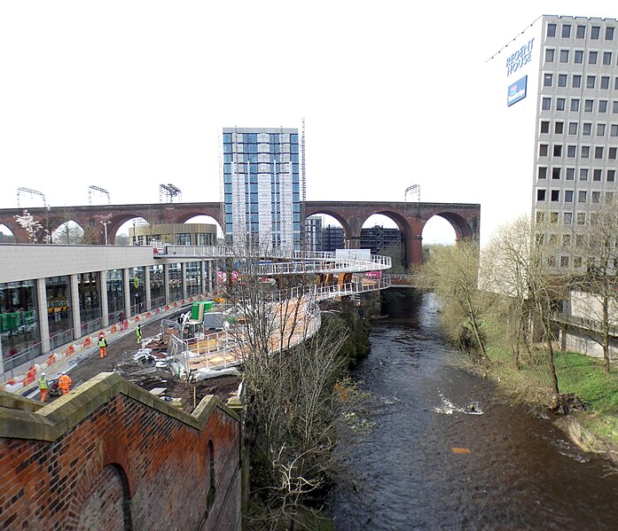
English: Until recently both banks of the river were lined with trees SJ8990 : River Mersey but the view has now been opened up considerably. In the foreground on the left are the old steps which have been cordoned off SJ8990 : Steps to the former bus station since work began on the new Transport Interchange. On the left is the now opened bus station. Construction is continuing with a spiral ramp leading from the bottom of the bus station. stretching out over the river and reaching the new Viaduct Park that sits atop the bus station. The view of the railway viaduct is spoilt by the Weir Mill development, a high rise apartment block being built on Astley Street. On the right is Regent House which includes offices and a Travelodge. |
| Date | |
| Source | From geograph.org.uk |
| Author | Gerald England |
| Permission (Reusing this file) |
Creative Commons Attribution Share-alike license 2.0 |
| Attribution (required by the license) | Gerald England / River Mersey from Wellington Viaduct / |
| Camera location | | View this and other nearby images on: OpenStreetMap |
|---|
.jpg¶ms=053.409402_N_-002.162877_E_globe:Earth_type:camera_source:geograph-osgb36(SJ89279030)_heading:247.00&language=en)
| Object location | | View this and other nearby images on: OpenStreetMap |
|---|
.jpg¶ms=053.409310_N_-002.163030_E_globe:Earth_class:object_type:object_source:geograph-osgb36(SJ89269029)_heading:247.00&language=en)
Licensing
edit.jpg&action=edit§ion=2)

|
This image was taken from the Geograph project collection. See this photograph's page on the Geograph website for the photographer's contact details. The copyright on this image is owned by Gerald England and is licensed for reuse under the Creative Commons Attribution-ShareAlike 2.0 license.
|
This file is licensed under the Creative Commons Attribution-Share Alike 2.0 Generic license.
Attribution: Gerald England
- You are free:
- to share – to copy, distribute and transmit the work
- to remix – to adapt the work
- Under the following conditions:
- attribution – You must give appropriate credit, provide a link to the license, and indicate if changes were made. You may do so in any reasonable manner, but not in any way that suggests the licensor endorses you or your use.
- share alike – If you remix, transform, or build upon the material, you must distribute your contributions under the same or compatible license as the original.
File history
Click on a date/time to view the file as it appeared at that time.
| Date/Time | Thumbnail | Dimensions | User | Comment | |
|---|---|---|---|---|---|
| current | 07:07, 1 April 2024 | | 1,920 × 1,651 (1.83 MB) | Hullian111-Flickr2Commons (talk | contribs) | == {{int:filedesc}} == {{Information |Description={{en|1=Until recently both banks of the river were lined with trees [https://www.geograph.org.uk/photo/2962718 SJ8990 : River Mersey] but the view has now been opened up considerably. In the foreground on the left are the old steps which have been cordoned off [https://www.geograph.org.uk/photo/7011471 SJ8990 : Steps to the former bus station] since work began on the new Transport Interchange. On the left is the now opened bus station. Constru... |
You cannot overwrite this file.
File usage on Commons
There are no pages that use this file.
.jpg&oldid=898037114)