File:River Mole Map.svg

Size of this PNG preview of this SVG file: 450 × 515 pixels. Other resolutions: 210 × 240 pixels | 419 × 480 pixels | 671 × 768 pixels | 895 × 1,024 pixels | 1,789 × 2,048 pixels.
Original file (SVG file, nominally 450 × 515 pixels, file size: 269 KB)
Captions
Captions
Add a one-line explanation of what this file represents
Summary edit
| Description |
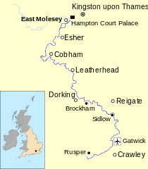
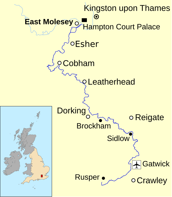
English: Map of the River Mole in south east England. Data from Open Street Maps. |
| Date | |
| Source | Own work |
| Author | Mertbiol |
Map created using data from the Open Street Maps.
Licensing edit
| I, the copyright holder of this work, release this work into the public domain. This applies worldwide. In some countries this may not be legally possible; if so: I grant anyone the right to use this work for any purpose, without any conditions, unless such conditions are required by law. |
File history
Click on a date/time to view the file as it appeared at that time.
| Date/Time | Thumbnail | Dimensions | User | Comment | |
|---|---|---|---|---|---|
| current | 15:42, 14 February 2010 | | 450 × 515 (269 KB) | Mertbiol (talk | contribs) | Still trying to get text to display correctly |
| 15:31, 14 February 2010 |  | 450 × 515 (273 KB) | Mertbiol (talk | contribs) | Attempt to sort out crop issues | |
| 15:27, 14 February 2010 |  | 674 × 772 (165 KB) | Mertbiol (talk | contribs) | Size page and attempt to sort out problem displaying text. | |
| 14:53, 14 February 2010 |  | 744 × 1,052 (168 KB) | Mertbiol (talk | contribs) | {{Information |Description={{en|1=Map of the River Mole in south east England}} |Source={{own}} |Author=Mertbiol |Date=2010-02-14 |Permission= |other_versions= }} Map created using data from the Open Source Maps. Category:Surrey |
You cannot overwrite this file.
File usage on Commons
The following page uses this file:
File usage on other wikis
The following other wikis use this file:
- Usage on de.wikipedia.org
- Usage on it.wikipedia.org
- Usage on pl.wikipedia.org
- Usage on sh.wikipedia.org
- Usage on www.wikidata.org