File:Robert M. Bashford House, Pinckney Street and Gilman Street, Mansion Hill, Madison, WI - 52762369282.jpg

Size of this preview: 800 × 600 pixels. Other resolutions: 320 × 240 pixels | 640 × 480 pixels | 1,024 × 768 pixels | 1,280 × 960 pixels | 2,560 × 1,919 pixels | 3,697 × 2,772 pixels.
Original file (3,697 × 2,772 pixels, file size: 4.36 MB, MIME type: image/jpeg)
Captions
Captions
Add a one-line explanation of what this file represents
Summary
edit
| Description |
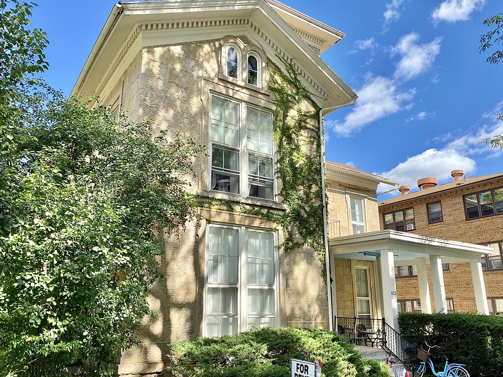
English: Built in 1858, this Italian Villa-variant Italianate-style house was designed by Napoleon Bonaparte Van Slyke and August Kutzbock, and was originally owned and lived in by H.K. Lawrence, a banker. The house was sold to Wisconsin Governor Edward Salomon in the early 1860s. The house was then acquired by Morris E. Fuller, an agricultural implement dealer, and his wife, Anna Fuller in 1865, and they lived there until 1889. In 1889, Sarah Fuller, their daughter, married Robert McKee Bashford, a lawyer who later became the Mayor of Madison and a Wisconsin State Senator, Wisconsin Supreme Court Justice, and ran a newspaper, while living at the house until his death in 1911. Between 1916 and 1928, the house was the home of Dr. Corydon Dwight and Bessie Dwight, whom helped establish the Vilas Park Zoo. In the 1930s, the mansion became a boardinghouse.
The house features sandstone block exterior walls with a front and side gable roof, eaves with dentils, a square tower with a low-slope pyramidal hipped roof, four-over-four double-hung windows, arched attic windows, decorative window trim, a front door with an arched transom, a front porch with square columns and a low-slope roof, a shorter rear ell with a gabled roof, and floor-height windows on the first floor. The house once featured many small balconies with brackets and railings on the second and third floors of the tower, and on the front gable, which have been removed, as well as a shallower, but more ornate porch at the same location as the present porch. The house was listed on the National Register of Historic Places in 1973, and is a contributing structure in the Mansion Hill Historic District, listed on the National Register of Historic Places in 1997. The house is presently utilized as an apartment building. |
| Date | |
| Source | https://www.flickr.com/photos/59081381@N03/52762369282/ |
| Author | w_lemay |
| Camera location | | View this and other nearby images on: OpenStreetMap |
|---|
Licensing
edit
This file is licensed under the Creative Commons Attribution-Share Alike 2.0 Generic license.
- You are free:
- to share – to copy, distribute and transmit the work
- to remix – to adapt the work
- Under the following conditions:
- attribution – You must give appropriate credit, provide a link to the license, and indicate if changes were made. You may do so in any reasonable manner, but not in any way that suggests the licensor endorses you or your use.
- share alike – If you remix, transform, or build upon the material, you must distribute your contributions under the same or compatible license as the original.
| This image was originally posted to Flickr by w_lemay at https://flickr.com/photos/59081381@N03/52762369282. It was reviewed on 22 March 2023 by FlickreviewR 2 and was confirmed to be licensed under the terms of the cc-by-sa-2.0. |
File history
Click on a date/time to view the file as it appeared at that time.
| Date/Time | Thumbnail | Dimensions | User | Comment | |
|---|---|---|---|---|---|
| current | 18:23, 22 March 2023 | | 3,697 × 2,772 (4.36 MB) | Ser Amantio di Nicolao (talk | contribs) | Uploaded a work by w_lemay from https://www.flickr.com/photos/59081381@N03/52762369282/ with UploadWizard |
You cannot overwrite this file.
File usage on Commons
There are no pages that use this file.