File:Robert Russa Moton, Virginia Historical Marker No. NW-12, and United Negro College Fund, Virginia Historical Marker No. NW-13, White Marsh, Virginia (14484834942).jpg

Original file (4,000 × 3,000 pixels, file size: 3.75 MB, MIME type: image/jpeg)
Captions
Captions
Summary edit
.jpg&action=edit§ion=1)
| Description |
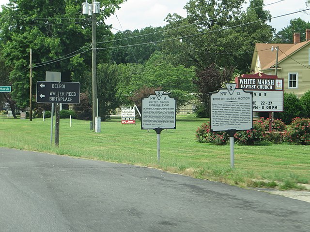
United Negro College Fund: Dr. Frederick D. Patterson founded the United Negro College fund in 1944. He and the presidents of the member colleges of the Fund began meeting in 1946 at Holly Knoll, the retirement home of the late Robert Russa Moton. Patterson had established Holly Knoll Associates in 1945 to serve as a conference center for black educators. Their meetings contributed to the growth and reputation of the United Negro College Fund, which aids more than 40 historically black colleges and provides student scholarships and faculty grants. The fund is known for its motto, "A mind is a terrible thing to waste." Robert Russa Moton: Robert Russa Moton was born in Amelia County, Virginia, on 26 August 1867, and was educated in a local freedmen's school and at Hampton Institute (now Hampton University). He served as an administrator at the institute from 1890 as president of the Tuskegee Institute. There Moton led the school to full collegiate accreditation, An advisor to five U.S. presidents and a founder of the Urban League, he retired to Holly Knoll (10 miles northwest) in 1935. Moton died on 31 May 1940. Holly Knoll was designated a National Historic Landmark in 1981. |
| Date | |
| Source | Robert Russa Moton, Virginia Historical Marker No. NW-12, and United Negro College Fund, Virginia Historical Marker No. NW-13, White Marsh, Virginia |
| Author | Ken Lund from Reno, Nevada, USA |
| Camera location | | View this and other nearby images on: OpenStreetMap |
|---|
.jpg¶ms=037.344697_N_-076.522275_E_globe:Earth_type:camera_source:Flickr_&language=en)
Licensing edit
.jpg&action=edit§ion=2)
- You are free:
- to share – to copy, distribute and transmit the work
- to remix – to adapt the work
- Under the following conditions:
- attribution – You must give appropriate credit, provide a link to the license, and indicate if changes were made. You may do so in any reasonable manner, but not in any way that suggests the licensor endorses you or your use.
- share alike – If you remix, transform, or build upon the material, you must distribute your contributions under the same or compatible license as the original.
| This image was originally posted to Flickr by Ken Lund at https://flickr.com/photos/75683070@N00/14484834942. It was reviewed on 12 April 2016 by FlickreviewR and was confirmed to be licensed under the terms of the cc-by-sa-2.0. |
File history
Click on a date/time to view the file as it appeared at that time.
| Date/Time | Thumbnail | Dimensions | User | Comment | |
|---|---|---|---|---|---|
| current | 06:00, 12 April 2016 | | 4,000 × 3,000 (3.75 MB) | Ser Amantio di Nicolao (talk | contribs) | Transferred from Flickr via Flickr2Commons |
You cannot overwrite this file.
File usage on Commons
The following page uses this file:
File usage on other wikis
The following other wikis use this file:
- Usage on azb.wikipedia.org
- Usage on en.wikipedia.org
- Usage on fa.wikipedia.org
- Usage on www.wikidata.org
.jpg&oldid=595789810)