File:Robinson Crusoe island.png

Size of this preview: 800 × 560 pixels. Other resolutions: 320 × 224 pixels | 640 × 448 pixels | 818 × 573 pixels.
Original file (818 × 573 pixels, file size: 613 KB, MIME type: image/png)
Captions
Captions
Add a one-line explanation of what this file represents
Summary
edit
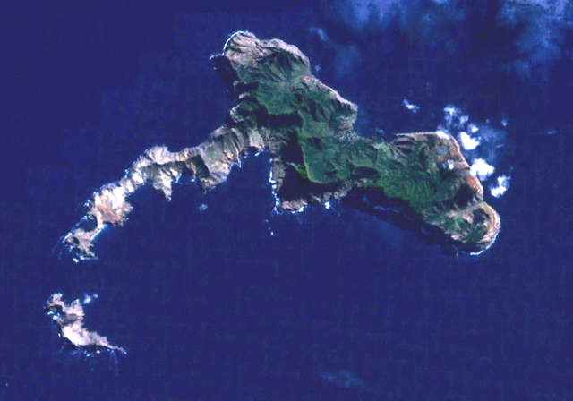
Robinson Crusoe Island (or Más a Tierra or Juan Fernandez island) and Santa Clara Islet (south). Town of San Juan Batista is on the northside. World Wind Landsat visual color.
Licensing
edit
| This image is in the public domain because it is a screenshot from NASA’s globe software World Wind using a public domain layer, such as Blue Marble, MODIS, Landsat, SRTM, USGS or GLOBE.
|
 |
File history
Click on a date/time to view the file as it appeared at that time.
| Date/Time | Thumbnail | Dimensions | User | Comment | |
|---|---|---|---|---|---|
| current | 16:26, 10 March 2006 | | 818 × 573 (613 KB) | Rasbak (talk | contribs) | brighter picture |
| 23:27, 29 September 2005 |  | 818 × 573 (626 KB) | Hardscarf (talk | contribs) | Robinson Crusoe Island (or Más a Tierra or Juan Fernandez island) and Santa Clara islet (south). San Juan Batista is on the northside. World Wind Landsat visual color. Category:Chile Chile {{PD-WorldWind |
You cannot overwrite this file.
File usage on Commons
There are no pages that use this file.
File usage on other wikis
The following other wikis use this file:
- Usage on arz.wikipedia.org
- Usage on ast.wikipedia.org
- Usage on az.wikipedia.org
- Usage on ceb.wikipedia.org
- Usage on de.wikipedia.org
- Usage on en.wikipedia.org
- Usage on es.wikipedia.org
- Usage on et.wikipedia.org
- Usage on fa.wikipedia.org
- Usage on fr.wikipedia.org
- Usage on he.wikivoyage.org
- Usage on hr.wikipedia.org
- Usage on hu.wikipedia.org
- Usage on it.wikivoyage.org
- Usage on ko.wikipedia.org
- Usage on nl.wikipedia.org
- Usage on nn.wikipedia.org
- Usage on pl.wikipedia.org
- Usage on ru.wikipedia.org
- Usage on sv.wikipedia.org
- Usage on www.wikidata.org
- Usage on zh.wikipedia.org