File:Rotes Luch.gif
Size of this preview: 800 × 560 pixels. Other resolutions: 320 × 224 pixels | 640 × 448 pixels | 1,062 × 743 pixels.
Original file (1,062 × 743 pixels, file size: 135 KB, MIME type: image/gif)
Captions
Captions
Add a one-line explanation of what this file represents
Summary edit
| Description |
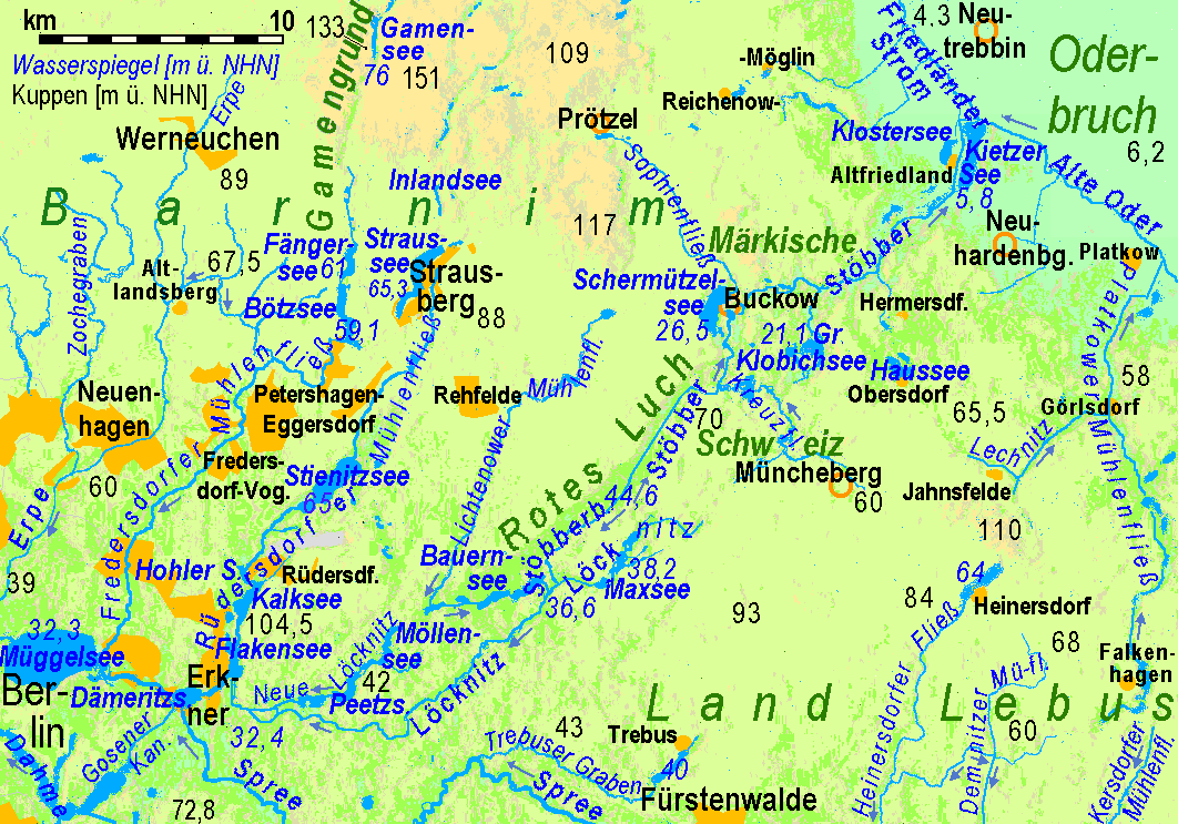
Parts of Barnim region between Berlin and the Oderbruch region:
|
| Source | http://www.maps-for-free.com + Openstreetmap |
| Author | Ulamm 01:50, 1 March 2008 (UTC) |
| Other versions | File:Rotes Luch.png |
Licensing edit
This file is licensed under the Creative Commons Attribution-Share Alike 3.0 Unported license.
- You are free:
- to share – to copy, distribute and transmit the work
- to remix – to adapt the work
- Under the following conditions:
- attribution – You must give appropriate credit, provide a link to the license, and indicate if changes were made. You may do so in any reasonable manner, but not in any way that suggests the licensor endorses you or your use.
- share alike – If you remix, transform, or build upon the material, you must distribute your contributions under the same or compatible license as the original.
File history
Click on a date/time to view the file as it appeared at that time.
| Date/Time | Thumbnail | Dimensions | User | Comment | |
|---|---|---|---|---|---|
| current | 22:53, 27 April 2016 | | 1,062 × 743 (135 KB) | Ulamm (talk | contribs) | some additions and a punctual correction |
| 11:46, 25 April 2016 |  | 1,062 × 743 (135 KB) | Ulamm (talk | contribs) | more names from official LGB: upper Löcknitz, Heinersdorfer & Demnitzer Fließe | |
| 08:46, 25 April 2016 |  | 1,062 × 743 (134 KB) | Ulamm (talk | contribs) | more rivers, more names | |
| 20:45, 22 April 2016 |  | 1,062 × 743 (127 KB) | Ulamm (talk | contribs) | improved dark blue colour, a bit of a key | |
| 20:10, 22 April 2016 |  | 1,062 × 743 (127 KB) | Ulamm (talk | contribs) | some more watercourses, some more places | |
| 12:30, 21 May 2012 |  | 1,062 × 743 (113 KB) | Ulamm (talk | contribs) | correction of "Scharmützelsee" to "Schermützelsee" | |
| 22:43, 4 March 2008 |  | 1,062 × 743 (113 KB) | Ulamm (talk | contribs) | ||
| 02:14, 2 March 2008 |  | 1,062 × 743 (110 KB) | Ulamm (talk | contribs) | ||
| 09:44, 1 March 2008 |  | 1,062 × 743 (490 KB) | Ulamm (talk | contribs) | ||
| 02:01, 1 March 2008 |  | 1,062 × 743 (491 KB) | Ulamm (talk | contribs) |
You cannot overwrite this file.
File usage on Commons
There are no pages that use this file.