File:Route of the 2015 Tour de France.png
Size of this preview: 554 × 600 pixels. Other resolutions: 222 × 240 pixels | 443 × 480 pixels | 709 × 768 pixels | 946 × 1,024 pixels | 1,892 × 2,048 pixels | 3,198 × 3,462 pixels.
Original file (3,198 × 3,462 pixels, file size: 2.76 MB, MIME type: image/png)
Captions
Captions
Add a one-line explanation of what this file represents
Summary
edit
| Description |
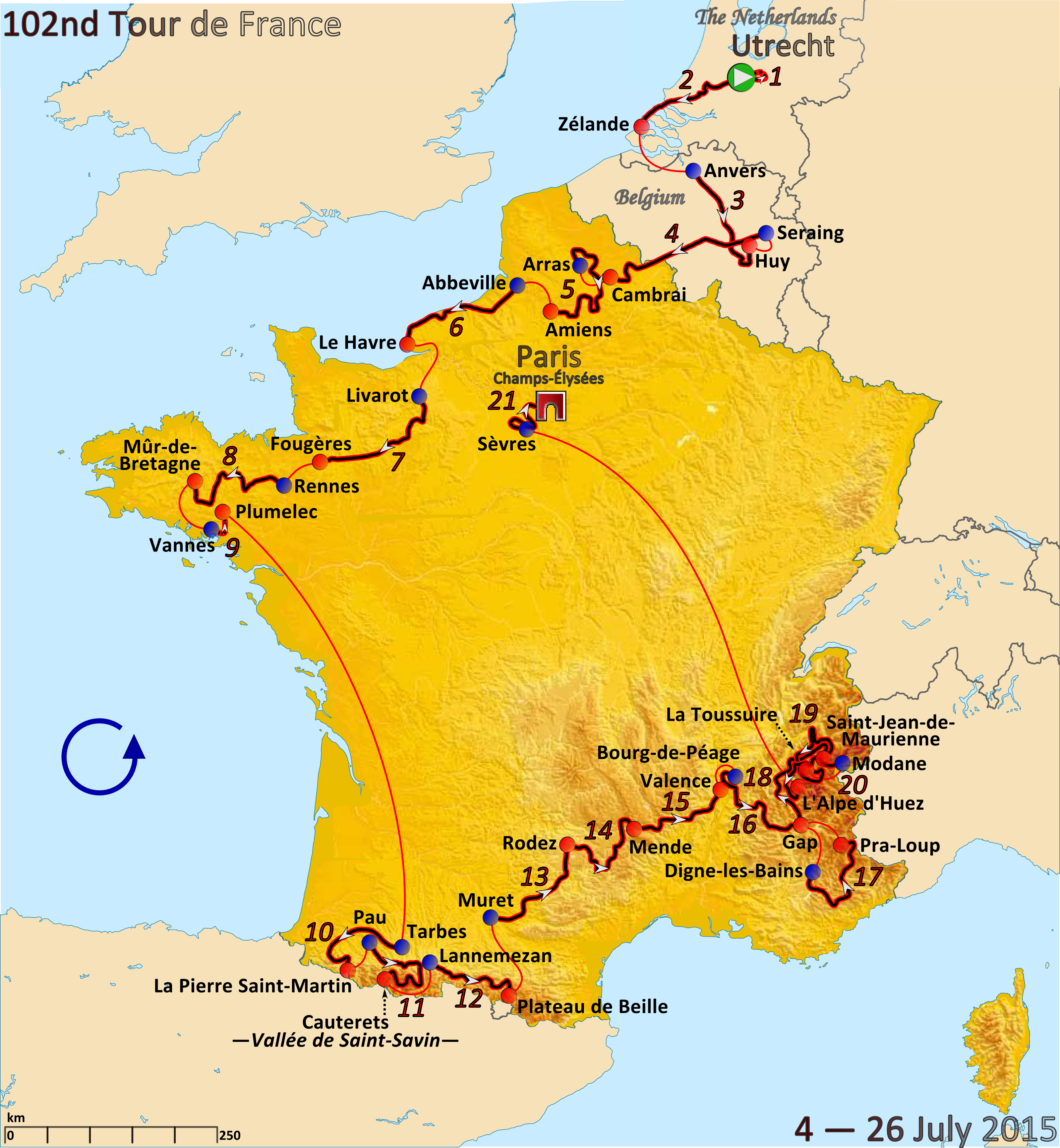
English: Map of the 2015 Tour de France drawn in Inkscape. |
| Date | |
| Source | Own work |
| Author | Andrei Loas |
Licensing
edit
I, the copyright holder of this work, hereby publish it under the following license:
This file is licensed under the Creative Commons Attribution-Share Alike 4.0 International license.
- You are free:
- to share – to copy, distribute and transmit the work
- to remix – to adapt the work
- Under the following conditions:
- attribution – You must give appropriate credit, provide a link to the license, and indicate if changes were made. You may do so in any reasonable manner, but not in any way that suggests the licensor endorses you or your use.
- share alike – If you remix, transform, or build upon the material, you must distribute your contributions under the same or compatible license as the original.
File history
Click on a date/time to view the file as it appeared at that time.
| Date/Time | Thumbnail | Dimensions | User | Comment | |
|---|---|---|---|---|---|
| current | 00:33, 21 November 2016 | | 3,198 × 3,462 (2.76 MB) | Andrei loas (talk | contribs) | Removed copyright text and distance. |
| 04:11, 23 April 2016 |  | 3,198 × 3,462 (2.8 MB) | Andrei loas (talk | contribs) | Decreased size of stage buttons to match all other maps. | |
| 00:12, 22 July 2015 |  | 3,198 × 3,462 (2.82 MB) | Andrei loas (talk | contribs) | User created page with UploadWizard |
You cannot overwrite this file.
File usage on Commons
The following 7 pages use this file:
- User:Chumwa/OgreBot/Potential transport maps/2016 April 21-30
- User:Chumwa/OgreBot/Potential transport maps/2016 November 21-30
- User:Chumwa/OgreBot/Transport Maps/2015 July 21-31
- User:Chumwa/OgreBot/Transport Maps/2016 April 21-30
- User:Chumwa/OgreBot/Transport Maps/2016 November 21-30
- User:Chumwa/OgreBot/Travel and communication maps/2016 April 21-30
- User:Chumwa/OgreBot/Travel and communication maps/2016 November 21-30
File usage on other wikis
The following other wikis use this file:
- Usage on en.wikipedia.org
- Usage on fy.wikipedia.org
- Usage on it.wikipedia.org
- Usage on sl.wikipedia.org
- Usage on tr.wikipedia.org