File:Routes du Kiang-Nan - btv1b52505950j (33 of 46).jpg

Size of this preview: 800 × 116 pixels. Other resolutions: 320 × 46 pixels | 640 × 93 pixels | 1,024 × 148 pixels | 1,280 × 185 pixels | 13,859 × 2,008 pixels.
Original file (13,859 × 2,008 pixels, file size: 2.59 MB, MIME type: image/jpeg)
Captions
Captions
Add a one-line explanation of what this file represents
Summary
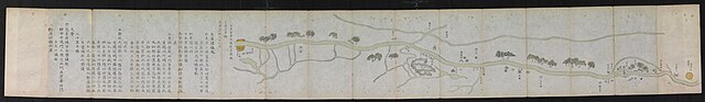
edit| English: A Chinese map of the Grand Canal near Huai'an during the Qing Dynasty from the Routes of Jiangnan
Français : Routes du Kiang-Nan ( |
|||||||||||||||||||||||||||
|---|---|---|---|---|---|---|---|---|---|---|---|---|---|---|---|---|---|---|---|---|---|---|---|---|---|---|---|
| Title |
English: A Chinese map of the Grand Canal near Huai'an during the Qing Dynasty from the Routes of Jiangnan
Français : Routes du Kiang-Nan |
||||||||||||||||||||||||||
| Description |
Français : Sujet : Jiangsu, Province de
Appartient à l’ensemble documentaire : PFceChi Couverture : Chine Langue : français Éditeur : [s.n.] |
||||||||||||||||||||||||||
| Date | 1732 | ||||||||||||||||||||||||||
| Collection |
|
||||||||||||||||||||||||||
| References |
Français : Notice du catalogue : http://catalogue.bnf.fr/ark:/12148/cb40747993h |
||||||||||||||||||||||||||
| Source/Photographer |
Français : Bibliothèque nationale de France, département Cartes et plans, GE FF-14551 (RES)
Bibliothèque nationale de France (33/46) |
||||||||||||||||||||||||||
| Permission (Reusing this file) |
|
||||||||||||||||||||||||||
| Other versions |
|
||||||||||||||||||||||||||

.jpg&action=edit§ion=1)
File history
Click on a date/time to view the file as it appeared at that time.
| Date/Time | Thumbnail | Dimensions | User | Comment | |
|---|---|---|---|---|---|
| current | 14:31, 25 July 2022 | 13,859 × 2,008 (2.59 MB) | Gzen92Bot (talk | contribs) | Gallica btv1b52505950j |
You cannot overwrite this file.
File usage on Commons
The following 2 pages use this file:
.jpg)
.jpg)
.jpg&oldid=826031221)