File:Royal Military Canal - geograph.org.uk - 733207.jpg
No higher resolution available.
Royal_Military_Canal_-_geograph.org.uk_-_733207.jpg (640 × 426 pixels, file size: 80 KB, MIME type: image/jpeg)
Captions
Captions
Add a one-line explanation of what this file represents
Summary edit
| Description |
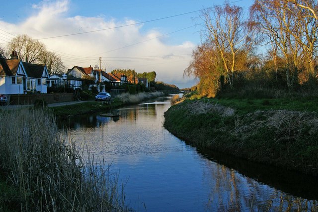
English: Royal Military Canal The Royal Military Canal was constructed between 1804 and 1809 as a defence against a Napoleonic invasion. It is 28 miles long the other end is in Seabrook. It was rendered somewhat obsolete by the battle of Trafalgar in 1805. In fact the whole idea was ill conceived as Napoleons army crossed almost every major river between Paris and Moscow and a fair few others besides. A minor ditch even if well defended would hardly be an obstacle for an army that could cross the English Channel. It did have an economic benefit as it has been a vital source of drainage for the Romney Marsh for 200 years. |
| Date | |
| Source | From geograph.org.uk |
| Author | Glyn Baker |
| Attribution (required by the license) | Glyn Baker / Royal Military Canal / |
| Camera location | | View this and other nearby images on: OpenStreetMap |
|---|
_heading:67.00&language=en)
| Object location | | View this and other nearby images on: OpenStreetMap |
|---|
_heading:67.00&language=en)
Licensing edit

|
This image was taken from the Geograph project collection. See this photograph's page on the Geograph website for the photographer's contact details. The copyright on this image is owned by Glyn Baker and is licensed for reuse under the Creative Commons Attribution-ShareAlike 2.0 license.
|
This file is licensed under the Creative Commons Attribution-Share Alike 2.0 Generic license.
Attribution: Glyn Baker
- You are free:
- to share – to copy, distribute and transmit the work
- to remix – to adapt the work
- Under the following conditions:
- attribution – You must give appropriate credit, provide a link to the license, and indicate if changes were made. You may do so in any reasonable manner, but not in any way that suggests the licensor endorses you or your use.
- share alike – If you remix, transform, or build upon the material, you must distribute your contributions under the same or compatible license as the original.
File history
Click on a date/time to view the file as it appeared at that time.
| Date/Time | Thumbnail | Dimensions | User | Comment | |
|---|---|---|---|---|---|
| current | 08:57, 19 February 2011 | | 640 × 426 (80 KB) | GeographBot (talk | contribs) | == {{int:filedesc}} == {{Information |description={{en|1=Royal Military Canal The Royal Military Canal was constructed between 1804 and 1809 as a defence against a Napoleonic invasion. It is 28 miles long the other end is in Seabrook. It was rendered some |
You cannot overwrite this file.
File usage on Commons
There are no pages that use this file.