File:Rpon1793wojew.png

Size of this preview: 666 × 600 pixels. Other resolutions: 267 × 240 pixels | 533 × 480 pixels | 853 × 768 pixels | 1,138 × 1,024 pixels | 1,524 × 1,372 pixels.
Original file (1,524 × 1,372 pixels, file size: 513 KB, MIME type: image/png)
Captions
Captions
Add a one-line explanation of what this file represents
Summary
edit
| Description |
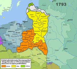
Polski: Mapa Rzeczypospolitej Obojga Narodów z podziałem na województwa utworzone 23 listopada 1793.
English: Map of Commonwealth of Both Nations with voivodships created in 23 november 1793. |
| Date | |
| Source | Own work, based on articles of polish Wikipedia |
| Author | GrzegorzusLudi |
Licensing
edit
I, the copyright holder of this work, hereby publish it under the following license:
| This file is made available under the Creative Commons CC0 1.0 Universal Public Domain Dedication. | |
| The person who associated a work with this deed has dedicated the work to the public domain by waiving all of their rights to the work worldwide under copyright law, including all related and neighboring rights, to the extent allowed by law. You can copy, modify, distribute and perform the work, even for commercial purposes, all without asking permission.
|
File history
Click on a date/time to view the file as it appeared at that time.
| Date/Time | Thumbnail | Dimensions | User | Comment | |
|---|---|---|---|---|---|
| current | 00:00, 26 January 2018 | | 1,524 × 1,372 (513 KB) | Poeticbent (talk | contribs) | brightness |
| 17:55, 25 January 2018 |  | 1,524 × 1,372 (472 KB) | Poeticbent (talk | contribs) | map area enlarged, to include all of Rzeczpospolita; cities added | |
| 18:16, 9 September 2014 |  | 739 × 1,200 (393 KB) | Poeticbent (talk | contribs) | filled in blank space, actual location on the map of the region | |
| 18:35, 26 August 2012 |  | 739 × 1,200 (29 KB) | GrzegorzusLudi (talk | contribs) | User created page with UploadWizard |
You cannot overwrite this file.
File usage on Commons
There are no pages that use this file.
File usage on other wikis
The following other wikis use this file:
- Usage on be-tarask.wikipedia.org
- Usage on be.wikipedia.org
- Usage on el.wikipedia.org
- Usage on en.wikipedia.org
- Usage on et.wikipedia.org
- Usage on fr.wikipedia.org
- Usage on lt.wikipedia.org
- Usage on lt.wikibooks.org
- Usage on pl.wikipedia.org
- Usage on ru.wikipedia.org