File:Rub al Khali.jpg

Original file (7,000 × 7,000 pixels, file size: 101.78 MB, MIME type: image/jpeg)
Captions
Captions
Summary edit
| Description |
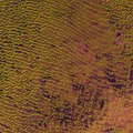
English: Rolling sand dunes in the expansive Rub’ al Khali desert on the southern Arabian Peninsula are pictured in this image from the Sentinel-2A satellite.
Also known at the ‘Empty Quarter’, the Rub’ al Khali is the largestcontiguous sand desertin the world. Precipitation rarely exceeds 35 mm a year and regular high temperatures are around 50°C. The yellow lines and dots in this false-colour image are sand dunes. Looking closer at the dunes in the lower right, many have three or more ‘arms’ shaped by changing wind directions and are known as ‘star dunes’. They tend to ‘grow’ upwards rather than laterally, and reach up to 250 m in height in some parts of the Rub’ al Khali. The dunes are interspersed with hardened flat plains – remnants of shallow lakes that existed thousands of years ago, formed by monsoon-like rains and runoff. The multispectral instrument on Sentinel-2 uses parts of the infrared spectrum to detect subtle changes in vegetation cover, but can also see changes in mineral composition where vegetation is sparse. In this image, shades of brown to bright purple show the mineral composition, possibly including salt or gypsum. This image – also featured on theEarth from Space video programme– was captured by Sentinel-2A on 22 December 2015. The satellite is the first in the two-satellite Sentinel-2 mission for Europe’s Copernicus programme, and carries a wide-swath high-resolution multispectral imager with 13 spectral bands for a new perspective of our land and vegetation. |
| Date | |
| Source | http://www.esa.int/spaceinimages/Images/2016/05/Rub_al_Khali |
| Author | European Space Agency |
| Permission (Reusing this file) |
Contains modified Copernicus Sentinel data [2016], processed by ESA,CC BY-SA 3.0 IGO |
| Other versions |
|
| Title | Rub al Khali |
| Keywords | Deserts |
| Set | Earth observation image of the week |
| Mission | Sentinel-2 |
| Activity | Observing the Earth |
Licensing edit
- You are free:
- to share – to copy, distribute and transmit the work
- to remix – to adapt the work
- Under the following conditions:
- attribution – You must give appropriate credit, provide a link to the license, and indicate if changes were made. You may do so in any reasonable manner, but not in any way that suggests the licensor endorses you or your use.
- share alike – If you remix, transform, or build upon the material, you must distribute your contributions under the same or compatible license as the original.

|
This image contains data from a satellite in the Copernicus Programme, such as Sentinel-1, Sentinel-2 or Sentinel-3. Attribution is required when using this image.
Attribution: Contains modified Copernicus Sentinel data {{{year}}}
The use of Copernicus Sentinel Data is regulated under EU law (Commission Delegated Regulation (EU) No 1159/2013 and Regulation (EU) No 377/2014). Relevant excerpts:
Free access shall be given to GMES dedicated data [...] made available through GMES dissemination platforms [...].
Access to GMES dedicated data [...] shall be given for the purpose of the following use in so far as it is lawful:
GMES dedicated data [...] may be used worldwide without limitations in time.
GMES dedicated data and GMES service information are provided to users without any express or implied warranty, including as regards quality and suitability for any purpose. |
File history
Click on a date/time to view the file as it appeared at that time.
| Date/Time | Thumbnail | Dimensions | User | Comment | |
|---|---|---|---|---|---|
| current | 10:15, 14 January 2021 | | 7,000 × 7,000 (101.78 MB) | StellarHalo (talk | contribs) | Uploaded a work by European Space Agency from http://www.esa.int/spaceinimages/Images/2016/05/Rub_al_Khali with UploadWizard |
You cannot overwrite this file.
File usage on Commons
There are no pages that use this file.