File:Rumbia 2013-07-01 1232Z.png
No higher resolution available.
Rumbia_2013-07-01_1232Z.png (320 × 320 pixels, file size: 107 KB, MIME type: image/png)
Captions
Captions
Add a one-line explanation of what this file represents
Summary
edit
| Description |
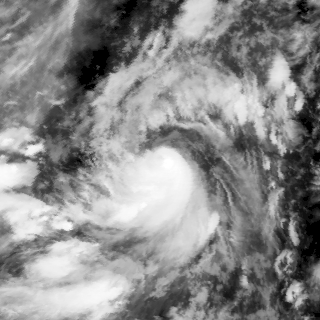
English: Severe Tropical Storm Rumbia shortly after its peak intensity as JTWC assessed, on July 1, 2013, captured on MTSAT-2 satellite. |
| Date | |
| Source | https://www.nrlmry.navy.mil/archdat/test/kml/TC/2013/WPAC/06W/visir/20130701.1232.MTSAT2.ir.06W.RUMBIA.WPAC.png |
| Author | Naval Research Laboratory |
| Metadata | https://www.nrlmry.navy.mil/archdat/test/kml/TC/2013/WPAC/06W/visir/20130701.1232.MTSAT2.ir.06W.RUMBIA.WPAC.png.txt |
| Satellite | MTSAT-2 |
| Camera location | | View this and other nearby images on: OpenStreetMap |
|---|
Licensing
edit
This file is a work of a sailor or employee of the U.S. Navy, taken or made as part of that person's official duties. As a work of the U.S. federal government, it is in the public domain in the United States.
|
 | |
| This file has been identified as being free of known restrictions under copyright law, including all related and neighboring rights. | ||
File history
Click on a date/time to view the file as it appeared at that time.
| Date/Time | Thumbnail | Dimensions | User | Comment | |
|---|---|---|---|---|---|
| current | 09:21, 29 January 2019 | | 320 × 320 (107 KB) | Nino Marakot (talk | contribs) | User created page with UploadWizard |
You cannot overwrite this file.
File usage on Commons
There are no pages that use this file.