File:Russian Empire 1745 General Map (Latin, HQ).jpg

Size of this preview: 800 × 461 pixels. Other resolutions: 320 × 184 pixels | 640 × 369 pixels | 1,024 × 590 pixels | 1,280 × 738 pixels | 2,560 × 1,476 pixels | 12,944 × 7,463 pixels.
Original file (12,944 × 7,463 pixels, file size: 38.11 MB, MIME type: image/jpeg)
Captions
Captions
Add a one-line explanation of what this file represents
| Warning | The original file is very high-resolution. It might not load properly or could cause your browser to freeze when opened at full size. |
|---|
Summary edit
| Description |
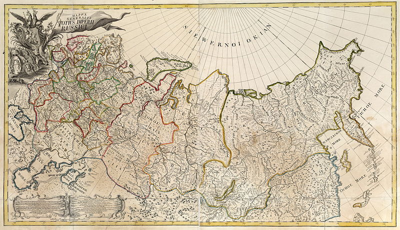
Русский: Генеральная карта Российской Империи из первого официального атласа Российской империи (1745). На латинском языке.
English: First official geographic atlas of the Russian Empire (1745). General Map of the Russian Empire in Latin. |
| Date | |
| Source |
Русский: Атлас Российский (1745)
English: Geographic atlas of the Russian Empire (1745) |
| Author | РАН (Russian Academy of Science) |
| Other versions |
|
.jpg)

.jpg)
.jpg&action=edit§ion=1)
Licensing edit
.jpg&action=edit§ion=2)
|
This work is in the public domain in its country of origin and other countries and areas where the copyright term is the author's life plus 100 years or fewer. | |
| This file has been identified as being free of known restrictions under copyright law, including all related and neighboring rights. | |
File history
Click on a date/time to view the file as it appeared at that time.
| Date/Time | Thumbnail | Dimensions | User | Comment | |
|---|---|---|---|---|---|
| current | 19:31, 23 February 2011 | | 12,944 × 7,463 (38.11 MB) | Transcend (rus) (talk | contribs) | {{LargeImage}} == {{int:filedesc}} == {{Information |Description={{ru|1=Генеральная карта Российской Империи из первого официального атласа Российской империи (1745). На лат |
You cannot overwrite this file.
File usage on Commons
The following 2 pages use this file:
File usage on other wikis
The following other wikis use this file:
- Usage on en.wikipedia.org
.jpg&oldid=508179560)