File:Russian occupation of Mykolaiv Oblast.png

Size of this preview: 652 × 600 pixels. Other resolutions: 261 × 240 pixels | 522 × 480 pixels | 835 × 768 pixels | 1,113 × 1,024 pixels | 1,300 × 1,196 pixels.
Original file (1,300 × 1,196 pixels, file size: 244 KB, MIME type: image/png)
Captions
Captions
Add a one-line explanation of what this file represents

|
File:Russian Occupation of Mykolaiv Oblast.svg is a vector version of this file. It should be used in place of this PNG file when not inferior.
File:Russian occupation of Mykolaiv Oblast.png → File:Russian Occupation of Mykolaiv Oblast.svg
For more information, see Help:SVG. |
 |
Summary
edit
|
This file may be updated to reflect new information. If you wish to use a specific version of the file without new updates being mirrored, please upload the required version as a separate file. |
| Description |
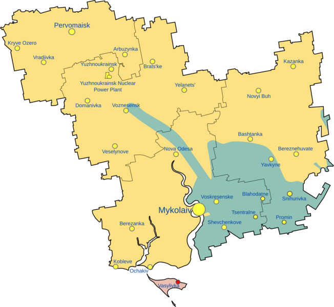
English: Map of Mykolaiv Oblast showing the rough zones of occupation during the southern offensive of the 2022 Russian invasion of Ukraine, as of August 2022.
Ukraine ( ) has maintained control over the north of the oblast. The Russian occupation ( ) extends through the southern border of the oblast, around the areas of Snihurivka & Tsentralne and also the whole of Kinburn Peninsula; in which includes the town of Pokrovka. Russian Armed Forces also formerly occupied large parts of Mykolaiv Raion including some parts of Mykolaiv, the capital city of the Oblast, as well as some border areas of Bashtanka Raion and also areas of Voznesensk Raion. These areas however would soon be recaptured by Ukraine. ( ) |
| Date | |
| Source | Own work |
| Author | Cryw 9 |
| Other versions |
[]
|


.png)


.png)


Licensing
edit
I, the copyright holder of this work, hereby publish it under the following license:
This file is licensed under the Creative Commons Attribution-Share Alike 4.0 International license.
- You are free:
- to share – to copy, distribute and transmit the work
- to remix – to adapt the work
- Under the following conditions:
- attribution – You must give appropriate credit, provide a link to the license, and indicate if changes were made. You may do so in any reasonable manner, but not in any way that suggests the licensor endorses you or your use.
- share alike – If you remix, transform, or build upon the material, you must distribute your contributions under the same or compatible license as the original.
File history
Click on a date/time to view the file as it appeared at that time.
| Date/Time | Thumbnail | Dimensions | User | Comment | |
|---|---|---|---|---|---|
| current | 15:14, 12 November 2022 | | 1,300 × 1,196 (244 KB) | Nahabino (talk | contribs) | Update, unification |
| 02:16, 28 August 2022 |  | 712 × 676 (18 KB) | Cryw 9 (talk | contribs) | fixing anti aliasing and fixing frontline slightly as it is on the war map | |
| 09:05, 27 August 2022 |  | 771 × 713 (288 KB) | Kaliper1 (talk | contribs) | Clarity Re-touch and Raions based of Міністерство розвитку громад та територій України (see: https://www.minregion.gov.ua/press/news/novi-rajony-karty-sklad/) | |
| 02:47, 26 August 2022 |  | 771 × 713 (18 KB) | Cryw 9 (talk | contribs) | marking some other areas as blue | |
| 01:28, 26 August 2022 |  | 771 × 713 (35 KB) | DinoSoupCanada (talk | contribs) | Color standardization with lost Russian territory | |
| 17:25, 24 August 2022 |  | 771 × 713 (18 KB) | Cryw 9 (talk | contribs) | adding more detail | |
| 17:56, 7 July 2022 |  | 771 × 713 (9 KB) | Cryw 9 (talk | contribs) | Uploaded own work with UploadWizard |
You cannot overwrite this file.
File usage on Commons
The following 52 pages use this file:
- Ukraine Regional Occupation Maps
- User:Minorax/SVG available/2022 November 7-12
- File:Dnipropetrovsk-poltava oblast occupation.png
- File:Dnipropetrovsk Oblast border skirmishes.png
- File:Kharkiv Oblast Control Evolution.png
- File:Kherson military–civilian administration.png
- File:Kherson military–civilian administration hatched.svg
- File:Occupation of Mykolaiv Oblast by Russia (With Cities).png
- File:Poltava oblast border skirmishes.png
- File:Russian Occupation of Chernihiv Oblast.svg
- File:Russian Occupation of Crimea.svg
- File:Russian Occupation of Dnipropetrovsk & Poltava Oblasts.svg
- File:Russian Occupation of Dnipropetrovsk Oblast.svg
- File:Russian Occupation of Donetsk Oblast.svg
- File:Russian Occupation of Kharkiv Oblast.svg
- File:Russian Occupation of Kherson Oblast.svg
- File:Russian Occupation of Kyiv Oblast.png
- File:Russian Occupation of Kyiv Oblast.svg
- File:Russian Occupation of Mykolaiv Oblast.svg
- File:Russian Occupation of Poltava Oblast.svg
- File:Russian Occupation of Sumy Oblast.svg
- File:Russian Occupation of Zaporizhzhia Oblast.svg
- File:Russian Occupation of Zhytomyr Oblast.svg
- File:Russian occupation of Chernihiv Oblast.png
- File:Russian occupation of Chernihiv Oblast peak.png
- File:Russian occupation of Donetsk Oblast.png
- File:Russian occupation of Kharkiv Oblast.png
- File:Russian occupation of Luhansk Oblast.png
- File:Russian occupation of Luhansk Oblast.svg
- File:Russian occupation of Mykolaiv Oblast.png
- File:Russian occupation of Sumy Oblast.png
- File:Russian occupation of Zhytomyr Oblast.png
- File:Zaporizhzhia frontline.png
- File:Zaporizhzhia military–civilian administration hatched.svg
- File:Zaporizhzhia region.png
- File:Днепропетровская область.png
- File:Донецкая область или Донецкая народная Республика.png
- File:Житомирская область.png
- File:Запорожская область.png
- File:Карта звільнених територій Житомирської області.png
- File:Киев.png
- File:Киевская область.png
- File:Крым (Автономная Республика).png
- File:Луганская область или Луганская Народная Республика.png
- File:Николаевская область 2.png
- File:Одесская область 2.png
- File:Полтавская область.png
- File:Севастополь.png
- File:Сумская область.png
- File:Харьковская область 2.png
- File:Херсонская область.png
- File:Черниговская область 2.png