File:Ryukyu Islands.svg

Size of this PNG preview of this SVG file: 800 × 552 pixels. Other resolutions: 320 × 221 pixels | 640 × 441 pixels | 1,024 × 706 pixels | 1,280 × 883 pixels | 2,560 × 1,766 pixels | 1,186 × 818 pixels.
Original file (SVG file, nominally 1,186 × 818 pixels, file size: 54 KB)
Captions
Captions
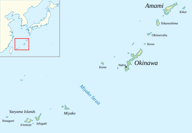
Main islands of the Ryukyu chain
Summary
edit
| Description |
English: Southern and central islands of the Ryukyu island chain (omits the northern Tokara and Osumi islands) |
|||||||||
| Date | ||||||||||
| Source |
Own work, using
|
|||||||||
| Creator | ||||||||||
| Geotemporal data | ||||||||||
| Spatial reference system | equirectangular | |||||||||
| Bounding box |
|
|||||||||
| SVG development | ||||||||||
Licensing
edit
I, the copyright holder of this work, hereby publish it under the following licenses:
This file is licensed under the Creative Commons Attribution-Share Alike 4.0 International license.
- You are free:
- to share – to copy, distribute and transmit the work
- to remix – to adapt the work
- Under the following conditions:
- attribution – You must give appropriate credit, provide a link to the license, and indicate if changes were made. You may do so in any reasonable manner, but not in any way that suggests the licensor endorses you or your use.
- share alike – If you remix, transform, or build upon the material, you must distribute your contributions under the same or compatible license as the original.

|
Permission is granted to copy, distribute and/or modify this document under the terms of the GNU Free Documentation License, Version 1.2 or any later version published by the Free Software Foundation; with no Invariant Sections, no Front-Cover Texts, and no Back-Cover Texts. A copy of the license is included in the section entitled GNU Free Documentation License. |
You may select the license of your choice.
File history
Click on a date/time to view the file as it appeared at that time.
| Date/Time | Thumbnail | Dimensions | User | Comment | |
|---|---|---|---|---|---|
| current | 21:13, 11 January 2023 | | 1,186 × 818 (54 KB) | Kanguole (talk | contribs) | add Naha |
| 14:05, 10 January 2023 |  | 1,186 × 818 (54 KB) | Kanguole (talk | contribs) | fix text | |
| 14:01, 10 January 2023 |  | 1,186 × 818 (53 KB) | Kanguole (talk | contribs) | label Miyako Strait; add inset context map | |
| 14:35, 9 January 2023 |  | 1,186 × 818 (19 KB) | Kanguole (talk | contribs) | a little more detail | |
| 15:41, 3 May 2019 |  | 512 × 353 (8 KB) | Kanguole (talk | contribs) | sans font for clarity | |
| 13:20, 3 May 2019 |  | 512 × 353 (8 KB) | Kanguole (talk | contribs) | {{Information |Description=Main islands of the Ryukyu chain. |Source={{own}} Polygons from [https://www.naturalearthdata.com/ Natural Earth] 1:10m. |Date=3 May 2019 |Author= Kanguole |Permission= |other_versions= }} Category:Maps of Ryukyu Islands Category:SVG maps of Japan |
You cannot overwrite this file.
File usage on Commons
There are no pages that use this file.
File usage on other wikis
The following other wikis use this file:
- Usage on ca.wikipedia.org
- Usage on en.wikipedia.org
- Usage on fr.wikipedia.org
- Usage on min.wiktionary.org
- Usage on www.wikidata.org