File:Sächsische Schweiz Klettergebiete.png

Size of this preview: 800 × 487 pixels. Other resolutions: 320 × 195 pixels | 640 × 390 pixels | 1,024 × 624 pixels | 1,499 × 913 pixels.
Original file (1,499 × 913 pixels, file size: 1.21 MB, MIME type: image/png)
Captions
Captions
Add a one-line explanation of what this file represents
Summary edit
| Description |
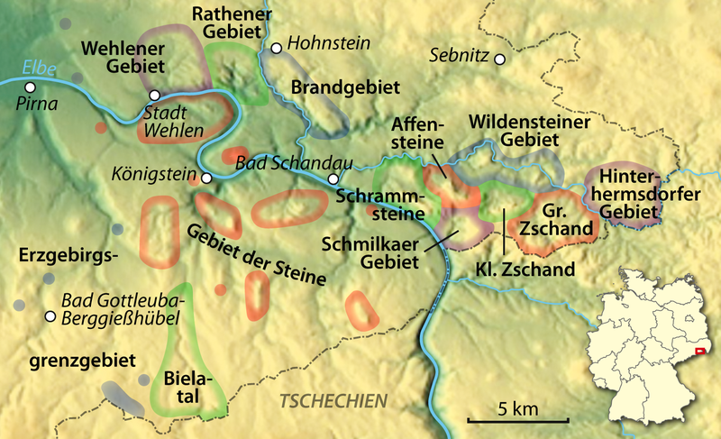
Deutsch: Klettergebiete der Sächsischen Schweiz
English: Climbing areas in Saxon Switzerland |
| Date | |
| Source |
Own work, using |
| Author | NordNordWest |
| Other versions | Derivative works of this file: Sächsische Schweiz Klettergebiete 2.png |
Licensing edit

|
Permission is granted to copy, distribute and/or modify this document under the terms of the GNU Free Documentation License, Version 1.2 or any later version published by the Free Software Foundation; with no Invariant Sections, no Front-Cover Texts, and no Back-Cover Texts. A copy of the license is included in the section entitled GNU Free Documentation License. |

|
This map has been made or improved in the German Kartenwerkstatt (Map Lab). You can propose maps to improve as well.
|
File history
Click on a date/time to view the file as it appeared at that time.
| Date/Time | Thumbnail | Dimensions | User | Comment | |
|---|---|---|---|---|---|
| current | 19:32, 30 July 2012 | | 1,499 × 913 (1.21 MB) | NordNordWest (talk | contribs) | upd |
| 19:40, 26 July 2012 |  | 1,499 × 913 (1.15 MB) | NordNordWest (talk | contribs) | c | |
| 19:36, 26 July 2012 |  | 1,499 × 913 (1.16 MB) | NordNordWest (talk | contribs) | == {{int:filedesc}} == {{Information |Description= {{de|Klettergebiete der Sächsischen Schweiz}} {{en|Climbing areas in Saxon Switzerland}} |Source={{Own}}, using * http://www.maps-for-free.com |Date={{Date|2012|07|26}} |Author={{U|NordNordWest}} |Per... |
You cannot overwrite this file.
File usage on Commons
The following 2 pages use this file:
File usage on other wikis
The following other wikis use this file:
- Usage on de.wikipedia.org
- Klettergebiet Sächsische Schweiz
- Wikipedia:Kartenwerkstatt/Archiv/2012-07
- Liste der Klettergipfel im Rathener Gebiet
- Liste der Klettergipfel im Wehlener Gebiet
- Liste der Klettergipfel im Brandgebiet
- Benutzer:Wahldresdner/Liste der Klettergipfel im Schrammsteingebiet
- Benutzer:Wahldresdner/Liste der Klettergipfel im Schmilkaer Gebiet
- Usage on en.wikipedia.org
- Usage on www.wikidata.org