File:Söíðanes11.jpg

Size of this preview: 800 × 338 pixels. Other resolutions: 320 × 135 pixels | 640 × 270 pixels | 1,024 × 433 pixels | 1,280 × 541 pixels | 3,211 × 1,357 pixels.
Original file (3,211 × 1,357 pixels, file size: 1.62 MB, MIME type: image/jpeg)
Captions
Captions
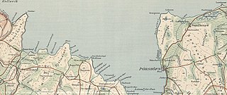
location of Sauðanes
Summary edit
| Description |
English: Sauðanes is a "churchstead" and the surrounding county was long named genetively after it until a remash of the counties in the 1930's |
| Date | |
| Source | map from the danish geometric institute from around 1931 |
| Author | the public danish map office |
Licensing edit
This file is licensed under the Creative Commons Attribution-Share Alike 4.0 International license.
- You are free:
- to share – to copy, distribute and transmit the work
- to remix – to adapt the work
- Under the following conditions:
- attribution – You must give appropriate credit, provide a link to the license, and indicate if changes were made. You may do so in any reasonable manner, but not in any way that suggests the licensor endorses you or your use.
- share alike – If you remix, transform, or build upon the material, you must distribute your contributions under the same or compatible license as the original.
File history
Click on a date/time to view the file as it appeared at that time.
| Date/Time | Thumbnail | Dimensions | User | Comment | |
|---|---|---|---|---|---|
| current | 17:08, 11 March 2021 | | 3,211 × 1,357 (1.62 MB) | Xypete (talk | contribs) | Uploaded a work by the public danish map office from map from the danish geometric institute from around 1931 with UploadWizard |
You cannot overwrite this file.
File usage on Commons
There are no pages that use this file.
File usage on other wikis
The following other wikis use this file:
- Usage on is.wikipedia.org