File:SAA Southern Africa network map.svg

Size of this PNG preview of this SVG file: 600 × 400 pixels. Other resolutions: 320 × 213 pixels | 640 × 427 pixels | 1,024 × 683 pixels | 1,280 × 853 pixels | 2,560 × 1,707 pixels.
Original file (SVG file, nominally 600 × 400 pixels, file size: 146 KB)
Captions
Captions
Add a one-line explanation of what this file represents
Summary edit
| Description |
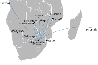
English: Map of the Southern Africa route network of South African Airways, not including its affiliates. Based on the February 2010 SAA timetable. See also File:SAA domestic network map.svg for domestic routes, and File:SAA international network map.svg for other international routes. |
| Date | |
| Source | Own work by uploader; country basemap from File:BlankMap-Africa.svg. |
| Author | Htonl |
| Other versions | Derivative works of this file: African quadripoint.svg |
Licensing edit
I, the copyright holder of this work, hereby publish it under the following licenses:
This file is licensed under the Creative Commons Attribution-Share Alike 3.0 Unported license.
- You are free:
- to share – to copy, distribute and transmit the work
- to remix – to adapt the work
- Under the following conditions:
- attribution – You must give appropriate credit, provide a link to the license, and indicate if changes were made. You may do so in any reasonable manner, but not in any way that suggests the licensor endorses you or your use.
- share alike – If you remix, transform, or build upon the material, you must distribute your contributions under the same or compatible license as the original.

|
Permission is granted to copy, distribute and/or modify this document under the terms of the GNU Free Documentation License, Version 1.2 or any later version published by the Free Software Foundation; with no Invariant Sections, no Front-Cover Texts, and no Back-Cover Texts. A copy of the license is included in the section entitled GNU Free Documentation License. |
You may select the license of your choice.
File history
Click on a date/time to view the file as it appeared at that time.
| Date/Time | Thumbnail | Dimensions | User | Comment | |
|---|---|---|---|---|---|
| current | 21:15, 20 February 2010 | | 600 × 400 (146 KB) | Htonl (talk | contribs) | text to paths |
| 21:12, 20 February 2010 |  | 600 × 400 (66 KB) | Htonl (talk | contribs) | remove affiliates | |
| 22:41, 7 July 2009 |  | 600 × 400 (290 KB) | Htonl (talk | contribs) | {{Information |Description={{en|1=Map of the Southern Africa route network of w:South African Airways and its affiliates w:South African Express and w:Airlink (all flights coded SAxxxx). See also File:SAA_domestic_network_map.svg for d |
You cannot overwrite this file.
File usage on Commons
The following page uses this file:
File usage on other wikis
The following other wikis use this file:
- Usage on af.wikipedia.org
- Usage on es.wikipedia.org
- Usage on incubator.wikimedia.org