File:SBAS Service Areas 2009.png
Size of this preview: 800 × 413 pixels. Other resolutions: 320 × 165 pixels | 640 × 331 pixels | 1,024 × 529 pixels | 1,500 × 775 pixels.
Original file (1,500 × 775 pixels, file size: 69 KB, MIME type: image/png)
Captions
Captions
Add a one-line explanation of what this file represents
| Description |
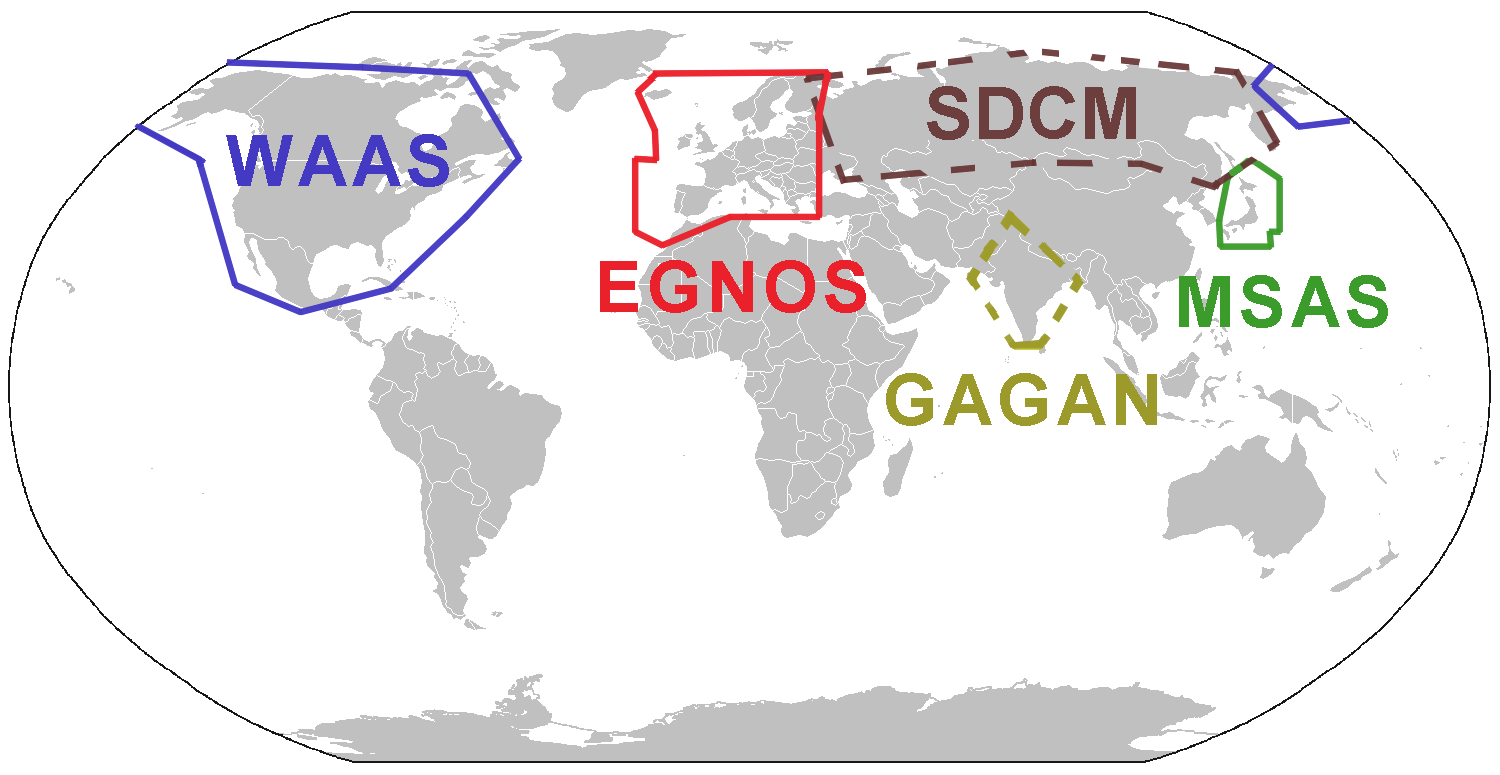
English: Map of Satellite Based Augmentation System (SBAS) existing and near future service areas 2009 |
| Date | (UTC) |
| Source | |
| Author |
|
| Other versions | Derivative works of this file: SBAS Service Areas.png |
| I, the copyright holder of this work, release this work into the public domain. This applies worldwide. In some countries this may not be legally possible; if so: I grant anyone the right to use this work for any purpose, without any conditions, unless such conditions are required by law. |
Original upload log edit
This image is a derivative work of the following images:
- File:BlankMap-World-alt.png licensed with PD-user
- 2008-11-20T01:04:05Z Tocino 1500x775 (17330 Bytes) Reverted to version as of 20:05, 25 February 2008
- 2008-02-25T20:17:43Z Nightstallion 1500x775 (68073 Bytes) Reverted to version as of :, 0 <>
- 2008-02-25T20:05:03Z Cp6 1500x775 (17330 Bytes) Reverted to version as of :, 0 <>
- 2008-02-25T11:14:23Z Nightstallion 1500x775 (68073 Bytes) Reverted to version as of :, 0 <>
- 2008-02-24T13:35:54Z Cp6 1500x775 (17330 Bytes) Reverted to version as of :, 0 <>
- 2008-02-24T12:42:58Z Nightstallion 1500x775 (68073 Bytes) Reverted to version as of :, 0 <>
- 2008-02-23T22:27:04Z Cp6 1500x775 (17330 Bytes) No OVERWRITING, look disc
- 2008-02-23T10:55:47Z Nightstallion 1500x775 (68073 Bytes) Reverted to version as of :, 0 <>
- 2008-02-22T22:05:45Z Cp6 1500x775 (17330 Bytes) It isn't internationally recognized, look at [[Kosovo relations.png]]
- 2008-02-18T23:11:12Z Hoshie 1500x775 (68073 Bytes) Added Kosovo since it has been internationally recognized.
- 2007-06-09T06:16:34Z David Levy 1500x775 (17330 Bytes) better compression
- 2006-08-09T10:38:17Z Roke 1500x775 (20539 Bytes) add montenegro after request
- 2006-03-28T06:16:15Z David Levy 1500x775 (17703 Bytes) better compression
- 2006-03-28T02:25:15Z E Pluribus Anthony 1500x775 (26394 Bytes) World map: blank, with borders (2005) [alt]
- 2006-03-26T20:47:13Z David Levy 1500x775 (17703 Bytes) better compression
- 2006-03-26T16:58:28Z E Pluribus Anthony 1488x755 (35471 Bytes) World map: blank, with borders (2005) [alt]
- 2006-02-25T18:40:08Z David Levy 1350x625 (14647 Bytes) better compression
- 2006-01-30T03:49:30Z E Pluribus Anthony 1357x628 (46316 Bytes) World map: blank, with borders (2005) [alt]
File history
Click on a date/time to view the file as it appeared at that time.
| Date/Time | Thumbnail | Dimensions | User | Comment | |
|---|---|---|---|---|---|
| current | 11:21, 19 July 2011 | | 1,500 × 775 (69 KB) | Persimplex (talk | contribs) | updated, corrected |
| 11:18, 19 July 2011 |  | 1,500 × 775 (69 KB) | Persimplex (talk | contribs) | updated, completed | |
| 12:40, 16 January 2009 |  | 1,500 × 775 (63 KB) | Persimplex (talk | contribs) | {{Information |Description=Map of Satellite Based Augmentation System (SBAS) existing and near future service areas 2009 |Source=*File:BlankMap-World-alt.png |Date=2009-01-16 12:38 (UTC) |Author=*derivative work: ~~~ *[[:File:BlankMap-World-alt.png| |
You cannot overwrite this file.
File usage on Commons
The following page uses this file: