File:SCORE Risk Charts Europe map.png

Size of this preview: 742 × 600 pixels. Other resolutions: 297 × 240 pixels | 594 × 480 pixels | 950 × 768 pixels | 1,267 × 1,024 pixels | 2,123 × 1,716 pixels.
Original file (2,123 × 1,716 pixels, file size: 474 KB, MIME type: image/png)
Captions
Captions
Add a one-line explanation of what this file represents
Summary
edit
| Description |
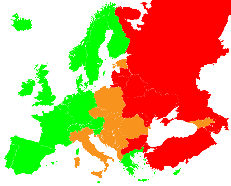
English: Europe map of SCORE Risk Charts (red colour - very high risk, green colour - low risk, orange colour - high risk) Polski: Ryzyko incydentu sercowo-naczyniowego wg skali SCORE (czerwony - kraje bardzo wysokiego ryzyka, pomarańczowy - kraje wysokiego ryzyka, zielono - kraje niskiego ryzyka) |
| Date | |
| Source | |
| Author |
|
| This is a retouched picture, which means that it has been digitally altered from its original version. Modifications: Highlighed SCORE cardiovascular risk. The original can be viewed here: Blank political map of Europe EU27 iso3166-1 code.svg:
|
Licensing
edit
I, the copyright holder of this work, hereby publish it under the following license:
This file is licensed under the Creative Commons Attribution-Share Alike 4.0 International license.
- You are free:
- to share – to copy, distribute and transmit the work
- to remix – to adapt the work
- Under the following conditions:
- attribution – You must give appropriate credit, provide a link to the license, and indicate if changes were made. You may do so in any reasonable manner, but not in any way that suggests the licensor endorses you or your use.
- share alike – If you remix, transform, or build upon the material, you must distribute your contributions under the same or compatible license as the original.
This image is a derivative work of the following images:
- File:Blank_map_of_Europe_EU27_iso3166-1_code.svg licensed with Cc-by-sa-2.5
- 2009-03-14T10:55:56Z Amibreton 454x450 (490785 Bytes) {{Information |Description={{en|1=Blank Map of Europe in SVG format oriented towards EU-27 (European Union of 27 member states) mapping. Each country has an id which is its ISO-3116-1-ALPHA2 code in lower case for easy colour
File history
Click on a date/time to view the file as it appeared at that time.
| Date/Time | Thumbnail | Dimensions | User | Comment | |
|---|---|---|---|---|---|
| current | 12:38, 14 September 2022 | | 2,123 × 1,716 (474 KB) | Рагин1987 (talk | contribs) | Extended map |
| 20:53, 25 August 2022 |  | 2,000 × 1,982 (422 KB) | Рагин1987 (talk | contribs) | Added Turkey (East Thrace) | |
| 23:04, 25 November 2014 |  | 2,000 × 1,982 (413 KB) | Fallaner (talk | contribs) | better colors | |
| 23:02, 25 November 2014 |  | 2,000 × 1,982 (413 KB) | Fallaner (talk | contribs) | better colours | |
| 22:08, 17 November 2014 |  | 2,000 × 1,982 (406 KB) | Fallaner (talk | contribs) | User created page with UploadWizard |
You cannot overwrite this file.
File usage on Commons
There are no pages that use this file.
File usage on other wikis
The following other wikis use this file: