File:SGMRT-LRT (zoom) map.svg

Size of this PNG preview of this SVG file: 800 × 448 pixels. Other resolutions: 320 × 179 pixels | 640 × 358 pixels | 1,024 × 573 pixels | 1,280 × 716 pixels | 2,560 × 1,432 pixels | 976 × 546 pixels.
Original file (SVG file, nominally 976 × 546 pixels, file size: 1.03 MB)
Captions
Captions
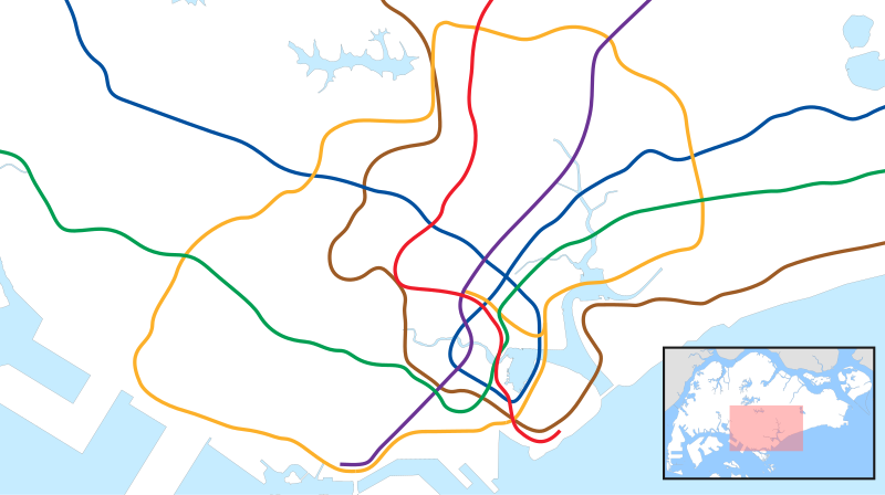
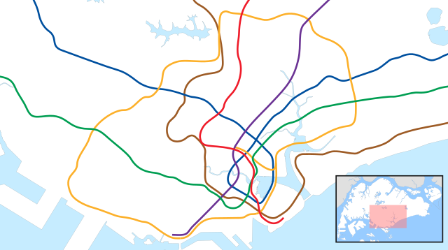
Zoomed in area on Singapore's MRT within Circle Line limits
Summary edit
_map.svg&action=edit§ion=1)
| Description |
English: Zoomed in area on Singapore's MRT within Circle Line limits |
| Date | |
| Source | Own work |
| Author | Map of Singapore and line layouts are taken from OpenStreetMap contributors and OneMap (official government source). Cleanup and editing by Seloloving. |
| SVG development |
Licensing edit
_map.svg&action=edit§ion=2)
This file is licensed under the Creative Commons Attribution-Share Alike 2.0 Generic license.
- You are free:
- to share – to copy, distribute and transmit the work
- to remix – to adapt the work
- Under the following conditions:
- attribution – You must give appropriate credit, provide a link to the license, and indicate if changes were made. You may do so in any reasonable manner, but not in any way that suggests the licensor endorses you or your use.
- share alike – If you remix, transform, or build upon the material, you must distribute your contributions under the same or compatible license as the original.
File history
Click on a date/time to view the file as it appeared at that time.
| Date/Time | Thumbnail | Dimensions | User | Comment | |
|---|---|---|---|---|---|
| current | 01:29, 3 August 2020 | | 976 × 546 (1.03 MB) | Seloloving (talk | contribs) | adjusted NSL and CCL slightly north |
| 01:06, 3 August 2020 |  | 976 × 546 (1.03 MB) | Seloloving (talk | contribs) | tried some improvements | |
| 01:38, 16 July 2020 |  | 976 × 546 (1.05 MB) | Seloloving (talk | contribs) | Uploaded own work with UploadWizard |
You cannot overwrite this file.
File usage on Commons
The following 6 pages use this file:
- User:Chumwa/OgreBot/Public transport information/2020 August 1-10
- User:Chumwa/OgreBot/Public transport information/2020 July 11-20
- User:Chumwa/OgreBot/Transport Maps/2020 August 1-10
- User:Chumwa/OgreBot/Transport Maps/2020 July 11-20
- User:Chumwa/OgreBot/Travel and communication maps/2020 August 1-10
- User:Chumwa/OgreBot/Travel and communication maps/2020 July 11-20
File usage on other wikis
The following other wikis use this file:
- Usage on bn.wikipedia.org
- Usage on en.wikipedia.org
- City Hall MRT station
- Raffles Place MRT station
- Outram Park MRT station
- Dhoby Ghaut MRT station
- HarbourFront MRT station
- Paya Lebar MRT station
- Buona Vista MRT station
- Marina Bay MRT station
- Chinatown MRT station
- Clarke Quay MRT station
- Little India MRT station
- Orchard MRT station
- Somerset MRT station
- Potong Pasir MRT station
- Newton MRT station
- Serangoon MRT station
- Farrer Park MRT station
- MacPherson MRT station
- Botanic Gardens MRT station
- Promenade MRT station
- Toa Payoh MRT station
- Novena MRT station
- Bugis MRT station
- Boon Keng MRT station
- Woodleigh MRT station
- Commonwealth MRT station
- Tiong Bahru MRT station
- Aljunied MRT station
- Lavender MRT station
- Tanjong Pagar MRT station
- Redhill MRT station
- Queenstown MRT station
- Nicoll Highway MRT station
- Stadium MRT station
- Mountbatten MRT station
- Dakota MRT station
- Tai Seng MRT station
- Bartley MRT station
- Lorong Chuan MRT station
- Bras Basah MRT station
- Esplanade MRT station
- Bayfront MRT station
- Downtown MRT station
- Telok Ayer MRT station
- One-north MRT station
- Pasir Panjang MRT station
- Haw Par Villa MRT station
View more global usage of this file.
_map.svg)
_map.svg&oldid=808379979)