File:SOUTH ABUTMENT FRAMED BLINDLY BECAUSE SLOPE - Laughingwater Creek Bridge, Spanning Laughingwater Creek at East Side Highway, Packwood, Lewis County, WA HAER WASH,21-PACK.V,3-5.tif
Size of this JPG preview of this TIF file: 800 × 572 pixels. Other resolutions: 320 × 229 pixels | 640 × 458 pixels | 1,024 × 733 pixels | 1,280 × 916 pixels | 2,560 × 1,832 pixels | 5,000 × 3,578 pixels.
Original file (5,000 × 3,578 pixels, file size: 17.06 MB, MIME type: image/tiff)
Captions
Captions
Add a one-line explanation of what this file represents
Summary edit
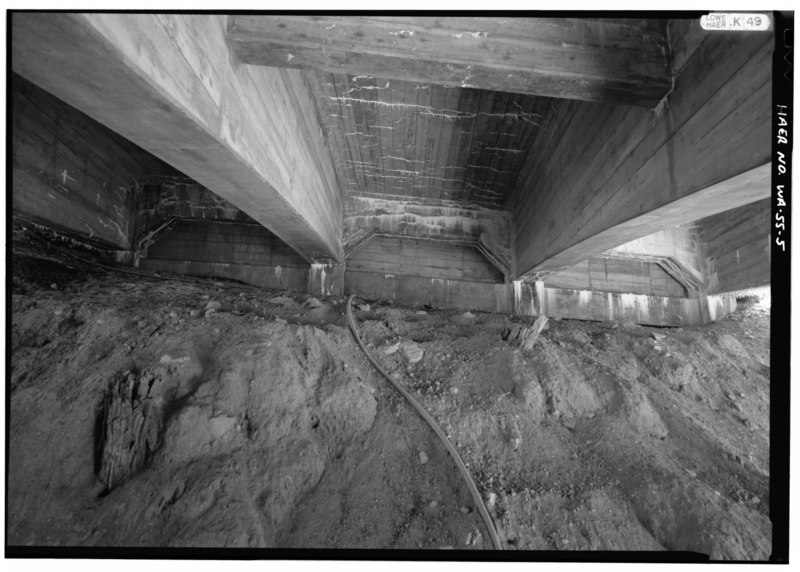
| SOUTH ABUTMENT FRAMED BLINDLY BECAUSE SLOPE - Laughingwater Creek Bridge, Spanning Laughingwater Creek at East Side Highway, Packwood, Lewis County, WA | ||||
|---|---|---|---|---|
| Photographer |
Lowe, Jet, creator |
|||
| Title |
SOUTH ABUTMENT FRAMED BLINDLY BECAUSE SLOPE - Laughingwater Creek Bridge, Spanning Laughingwater Creek at East Side Highway, Packwood, Lewis County, WA |
|||
| Description |
Polk, C G; Simpson, W D; Joplin and Elder; Bureau of Public Roads; Parks, James; Wall, J A; Gingles, John, sponsor; Briggle, William, sponsor; Croteau, Todd, project manager; Quin, Richard, historian; Fish, Bryan D, delineator; Trettel, Daniela, delineator; Dickson, Julie Ann, delineator; Lowe, Jet, photographer |
|||
| Depicted place | Washington; Lewis County; Packwood | |||
| Date | 1992 | |||
| Dimensions | 5 x 7 in. | |||
| Current location |
Library of Congress Prints and Photographs Division Washington, D.C. 20540 USA http://hdl.loc.gov/loc.pnp/pp.print |
|||
| Accession number |
HAER WASH,21-PACK.V,3-5 |
|||
| Credit line |
|
|||
| Notes |
|
|||
| Source | https://www.loc.gov/pictures/item/wa0365.photos.370035p | |||
| Permission (Reusing this file) |
|
|||

File history
Click on a date/time to view the file as it appeared at that time.
| Date/Time | Thumbnail | Dimensions | User | Comment | |
|---|---|---|---|---|---|
| current | 20:30, 4 August 2014 |  | 5,000 × 3,578 (17.06 MB) | Fæ (talk | contribs) | GWToolset: Creating mediafile for Fæ. HABS 2014-08-04 (3601:3800) Penultimate Tranche! |
You cannot overwrite this file.
File usage on Commons
The following page uses this file: