File:STAIRWAY, GROUND FLOOR, TOWER - Old South Meetinghouse, Washington and Milk Streets, Boston, Suffolk County, MA HABS MASS,13-BOST,54-16.tif

Size of this JPG preview of this TIF file: 476 × 600 pixels. Other resolutions: 190 × 240 pixels | 381 × 480 pixels | 609 × 768 pixels | 812 × 1,024 pixels | 1,625 × 2,048 pixels | 3,961 × 4,992 pixels.
Original file (3,961 × 4,992 pixels, file size: 18.86 MB, MIME type: image/tiff)
Captions
Captions
Add a one-line explanation of what this file represents
Summary edit
| STAIRWAY, GROUND FLOOR, TOWER - Old South Meetinghouse, Washington and Milk Streets, Boston, Suffolk County, MA | ||||
|---|---|---|---|---|
| Photographer |
Hubbard, Cortlandt V. |
|||
| Title |
STAIRWAY, GROUND FLOOR, TOWER - Old South Meetinghouse, Washington and Milk Streets, Boston, Suffolk County, MA |
|||
| Depicted place | Massachusetts; Suffolk County; Boston | |||
| Date | Documentation compiled after 1933; 1968 | |||
| Dimensions | 4 x 5 in. | |||
| Current location |
Library of Congress Prints and Photographs Division Washington, D.C. 20540 USA http://hdl.loc.gov/loc.pnp/pp.print |
|||
| Accession number |
HABS MASS,13-BOST,54-16 |
|||
| Credit line |
|
|||
| Notes |
|
|||
| References |
|
|||
| Source | https://www.loc.gov/pictures/item/ma0470.photos.076249p | |||
| Permission (Reusing this file) |
|
|||

| Camera location | | View this and other nearby images on: OpenStreetMap |
|---|
File history
Click on a date/time to view the file as it appeared at that time.
| Date/Time | Thumbnail | Dimensions | User | Comment | |
|---|---|---|---|---|---|
| current | 19:57, 20 July 2014 | 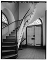 | 3,961 × 4,992 (18.86 MB) | Fæ (talk | contribs) | GWToolset: Creating mediafile for Fæ. HABS 20 July 2014 (1401:1600) |
You cannot overwrite this file.
File usage on Commons
The following page uses this file: