File:STS007-03-0058.jpg

Size of this preview: 593 × 599 pixels. Other resolutions: 238 × 240 pixels | 475 × 480 pixels | 760 × 768 pixels | 1,014 × 1,024 pixels | 2,027 × 2,048 pixels | 5,266 × 5,320 pixels.
Original file (5,266 × 5,320 pixels, file size: 13.31 MB, MIME type: image/jpeg)
Captions
Captions
Add a one-line explanation of what this file represents
Summary
edit
| Description |
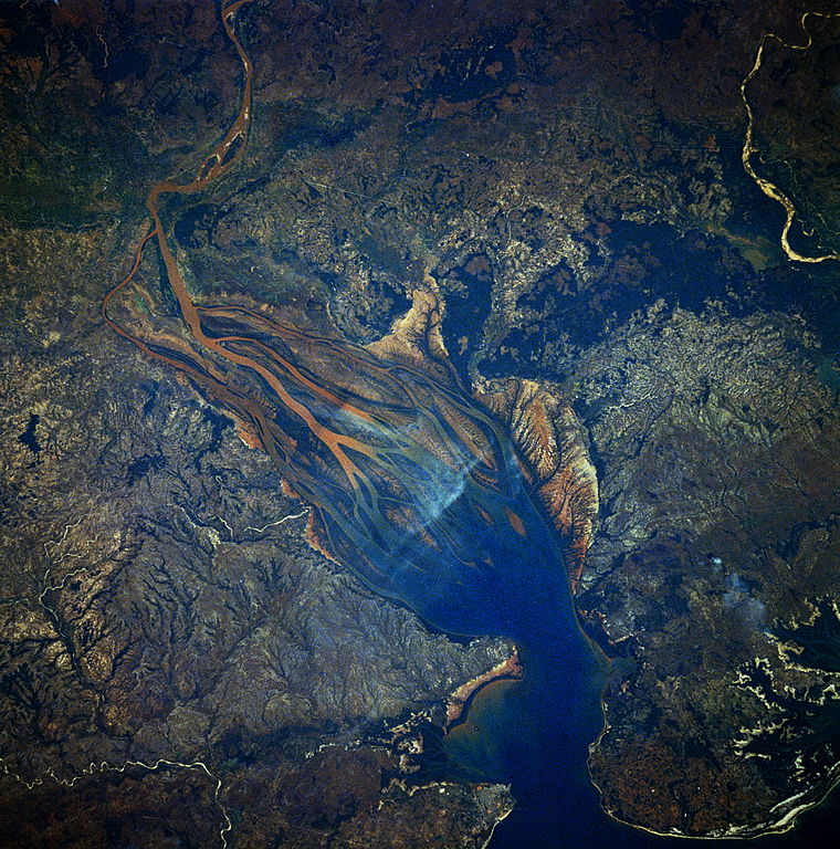
English: STS007-03-0058 Betsiboka River Delta, Madagascar June 1983 Dramatic evidence of the catastrophic erosion of northwestern Madagascar is revealed in this near-vertical, June 1983 photograph of the rapidly expanding Betsiboka River Delta. The removal of the native forest for cultivation and pastureland during the past 50 years has led to massive annual soil losses approaching 112 tons per acre (250 metric tons per hectare) in some regions of the island, the largest amount recorded anywhere in the world. The photograph provides convincing evidence of the result of this process, as the effects of water erosion are seen throughout the 1544-square-mile (4000-square-kilometer) land surface area of the photograph. The delta continues to build toward the mouth of Bombetoka Bay, which enters the Mozambique Channel. |
| Date | |
| Source | http://spaceflight.nasa.gov/gallery/ |
| Author | NASA |
Licensing
edit
| This file is in the public domain in the United States because it was solely created by NASA. NASA copyright policy states that "NASA material is not protected by copyright unless noted". (See Template:PD-USGov, NASA copyright policy page or JPL Image Use Policy.) | ||
 |
Warnings:
|
File history
Click on a date/time to view the file as it appeared at that time.
| Date/Time | Thumbnail | Dimensions | User | Comment | |
|---|---|---|---|---|---|
| current | 08:30, 21 June 2013 | | 5,266 × 5,320 (13.31 MB) | Askeuhd (talk | contribs) | User created page with UploadWizard |
You cannot overwrite this file.
File usage on Commons
There are no pages that use this file.