File:SWE-Map Rike-2008-29-07.png
No higher resolution available.
SWE-Map_Rike-2008-29-07.png (277 × 594 pixels, file size: 25 KB, MIME type: image/png)
Captions
Captions
Add a one-line explanation of what this file represents
| Description |
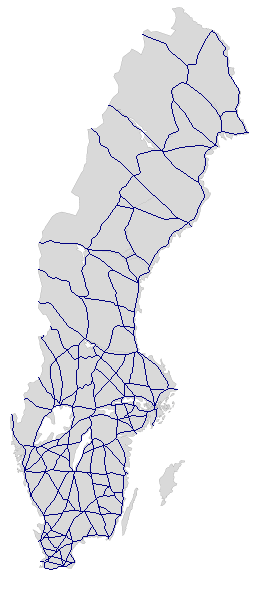
English: Sweden's network of National routes (roads), European routes within the country included. No numbers are shown. The map is based on a blank map of Sweden (Image:SWE-Map Rike.svg). For info on how to easiest edit the map see SWE-Map Documentation Svenska: Sveriges riksvägsvägnät, Europavägarna i landet inkluderade. Nummer visas ej. Kartan är baserad på en blank Sverigekarta (Image:SWE-Map Rike.svg). För information om hur kartan lättast modifieras se SWE-Map Documentation |
| Date | (UTC) |
| Source | |
| Author |
|
| This is a retouched picture, which means that it has been digitally altered from its original version. Modifications: The network of national routes (riksvägar) is shown.. The original can be viewed here: SWE-Map Rike.svg:
|
I, the copyright holder of this work, hereby publish it under the following license:
This file is licensed under the Creative Commons Attribution-Share Alike 2.5 Generic license.
- You are free:
- to share – to copy, distribute and transmit the work
- to remix – to adapt the work
- Under the following conditions:
- attribution – You must give appropriate credit, provide a link to the license, and indicate if changes were made. You may do so in any reasonable manner, but not in any way that suggests the licensor endorses you or your use.
- share alike – If you remix, transform, or build upon the material, you must distribute your contributions under the same or compatible license as the original.
Original upload log edit
This image is a derivative work of the following images:
- Image:SWE-Map_Rike.svg licensed with Cc-by-sa-2.5
- 2008-06-13T11:25:55Z Lokal Profil 255x580 (44016 Bytes) made the fill colour slightly darker (~15% gray)
- 2007-04-15T22:51:05Z Lokal Profil 255x580 (44016 Bytes) Inverted colours, reduced amount of white space on the sides
- 2007-04-11T23:48:00Z Lokal Profil 287x606 (44008 Bytes) Metadata correction
- 2007-04-11T23:39:36Z Lokal Profil 287x606 (44000 Bytes) {{Information |Description={{en|An outline of the national borders of Sweden. For info on how to easiest edit the map see [[:User:Lokal Profil/SWE-Map Documentation|SWE-Map Documentation]]}} {{sv|Sveriges riksgräns. För inf
Uploaded with derivativeFX
File history
Click on a date/time to view the file as it appeared at that time.
| Date/Time | Thumbnail | Dimensions | User | Comment | |
|---|---|---|---|---|---|
| current | 18:09, 29 July 2008 | | 277 × 594 (25 KB) | Skvattram~commonswiki (talk | contribs) | {{Information |Description={{en|Sweden's network of National routes (roads), European routes within the country included. No numbers are shown. The map is based on a blank map of Sweden (Image:SWE-Map Rike.svg). For info on how to easiest edit the map see |
You cannot overwrite this file.
File usage on Commons
There are no pages that use this file.