File:Sachsenring1.png

Size of this preview: 800 × 418 pixels. Other resolutions: 320 × 167 pixels | 640 × 334 pixels | 932 × 487 pixels.
Original file (932 × 487 pixels, file size: 299 KB, MIME type: image/png)
Captions
Captions
Add a one-line explanation of what this file represents
Summary
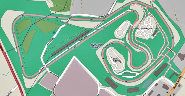
edit| Description |
This map was created from OpenStreetMap project data, collected by the community. This map may be incomplete, and may contain errors. Don't rely solely on it for navigation. |
| Date | |
| Source | openstreetmap.org |
| Creator | |
| Permission (Reusing this file) |
OpenStreetMap data and maps are licensed under the Creative Commons Attribution-ShareAlike 2.0 license (CC-BY-SA 2.0). This file is licensed under the Creative Commons Attribution-Share Alike 2.0 Generic license.
|
| Georeferencing | If inappropriate please set warp_status = skip to hide. |
| Other versions |
|


| Camera location | | View this and other nearby images on: OpenStreetMap |
|---|

|
File:Sachsenring.svg is a vector version of this file. It should be used in place of this PNG file when not inferior.
File:Sachsenring1.png → File:Sachsenring.svg
For more information, see Help:SVG. |
 |

|
This file has been superseded by Sachsenring.svg. It is recommended to use the other file. Please note that deleting superseded images requires consent.
|

|
This map image could be re-created using vector graphics as an SVG file. This has several advantages; see Commons:Media for cleanup for more information. If an SVG form of this image is available, please upload it and afterwards replace this template with
{{vector version available|new image name}}.
It is recommended to name the SVG file “Sachsenring1.svg”—then the template Vector version available (or Vva) does not need the new image name parameter. |
File history
Click on a date/time to view the file as it appeared at that time.
| Date/Time | Thumbnail | Dimensions | User | Comment | |
|---|---|---|---|---|---|
| current | 20:41, 16 October 2012 | | 932 × 487 (299 KB) | कार (talk | contribs) | {{Information |Description ={{de|1=Sachsenring}} |Source ={{own}} |Author =Auto1234 |Date =16. Oktober 2012 |Permission = |other_versions = }} Category:Sachsenring circuit maps |
You cannot overwrite this file.
File usage on Commons
The following 5 pages use this file:
File usage on other wikis
The following other wikis use this file:
- Usage on de.wikipedia.org