File:Saint-Martin Island map-fr.svg

Size of this PNG preview of this SVG file: 796 × 600 pixels. Other resolutions: 319 × 240 pixels | 637 × 480 pixels | 1,020 × 768 pixels | 1,280 × 964 pixels | 2,560 × 1,928 pixels | 1,102 × 830 pixels.
Original file (SVG file, nominally 1,102 × 830 pixels, file size: 867 KB)
Captions
Captions
Add a one-line explanation of what this file represents
Summary
edit| Camera location | | View this and other nearby images on: OpenStreetMap |
|---|
| Description |
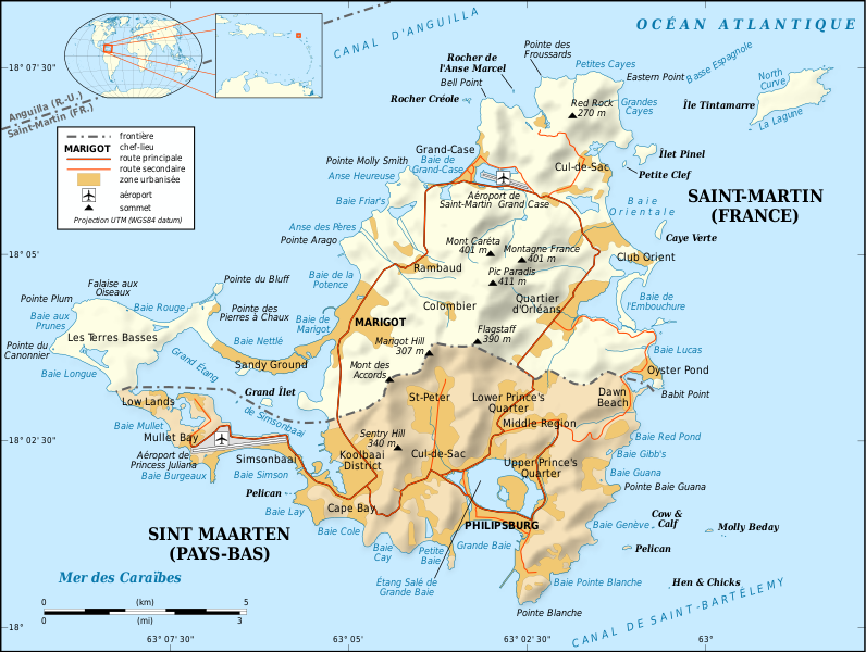
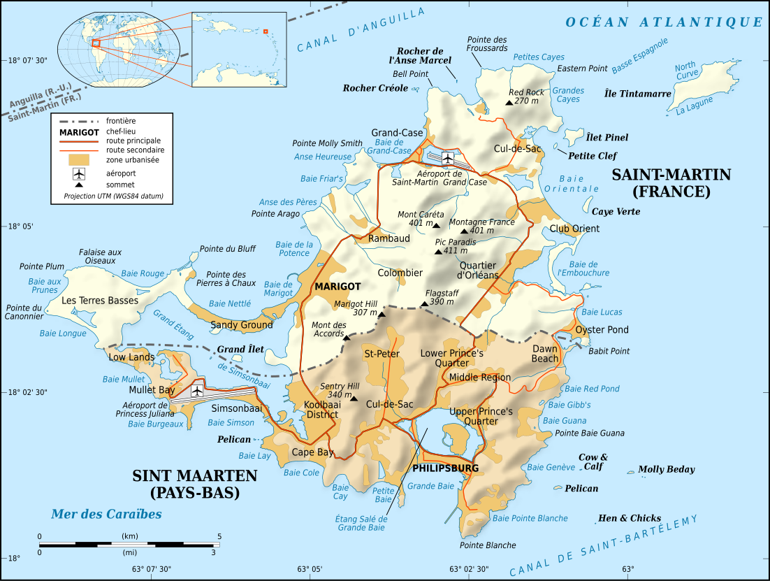
English: Map in French of the Caribbean island of Saint-Martin / Sint Maarten, divided between French and Dutch halves.
Note: the shaded relief is a raster image embedded in the SVG file. Français : Carte en français de l'île de Saint-Martin / Sint Maarten dans les Antilles, divisée en une partie française et une partie néerlandaise. Note : les ombres du relief sont une image bitmap embarquée dans le fichier SVG.
|
||
| Date | |||
| Source |
Own work
|
||
| Author | Eric Gaba (Sting - fr:Sting) | ||
| Permission (Reusing this file) |
|
||
| Other versions |
[]
Same base map but smaller and without topography:
|


|
This SVG file contains embedded text that can be translated into your language, using any capable SVG editor, text editor or the SVG Translate tool. For more information see: About translating SVG files. |
Licensing
edit
I, the copyright holder of this work, hereby publish it under the following licenses:

|
Permission is granted to copy, distribute and/or modify this document under the terms of the GNU Free Documentation License, Version 1.2 or any later version published by the Free Software Foundation; with no Invariant Sections, no Front-Cover Texts, and no Back-Cover Texts. A copy of the license is included in the section entitled GNU Free Documentation License. |
This file is licensed under the Creative Commons Attribution-Share Alike 4.0 International, 3.0 Unported, 2.5 Generic, 2.0 Generic and 1.0 Generic license.
- You are free:
- to share – to copy, distribute and transmit the work
- to remix – to adapt the work
- Under the following conditions:
- attribution – You must give appropriate credit, provide a link to the license, and indicate if changes were made. You may do so in any reasonable manner, but not in any way that suggests the licensor endorses you or your use.
- share alike – If you remix, transform, or build upon the material, you must distribute your contributions under the same or compatible license as the original.
You may select the license of your choice.
File history
Click on a date/time to view the file as it appeared at that time.
| Date/Time | Thumbnail | Dimensions | User | Comment | |
|---|---|---|---|---|---|
| current | 17:58, 16 April 2009 | | 1,102 × 830 (867 KB) | Sting (talk | contribs) | Fonts issues correction |
| 03:42, 17 January 2009 |  | 1,102 × 830 (867 KB) | Sting (talk | contribs) | == Summary == {{Location|18|04|00|N|63|03|30|W|scale:100000}} <br/> {{Information |Description={{en|Map in French of the Caribbean island of Saint-Martin / Sint Maarten, divided between French and Dutch halves.<br/> ''Note: the shaded |
You cannot overwrite this file.
File usage on Commons
The following 13 pages use this file:
- Atlas of Saint-Martin
- Atlas of Sint Maarten
- Maps of Saint Martin island
- User:Sting
- User:Sting/Gallery: Regional maps
- File:Saint-Martin Island map-be.svg
- File:Saint-Martin Island map-en.svg
- File:Saint-Martin Island map-es.svg
- File:Saint-Martin Island map-fr.svg
- File:Saint-Martin Island topographic map-en.svg
- File:Saint-Martin Island topographic map-fr.svg
- File:Saint-Martin Island topographic map-mk.svg
- Template:Other versions/Saint-Martin Island topographic map
File usage on other wikis
The following other wikis use this file:
- Usage on als.wikipedia.org
- Usage on ast.wikipedia.org
- Usage on az.wikipedia.org
- Usage on br.wikipedia.org
- Usage on ca.wikipedia.org
- Usage on da.wikipedia.org
- Usage on de.wikipedia.org
- Usage on en.wikipedia.org
- Usage on eo.wikipedia.org
- Usage on fi.wikipedia.org
- Usage on frr.wikipedia.org
- Usage on fr.wikipedia.org
- Saint-Martin (île)
- Histoire de Saint-Martin
- Île Tintamarre
- Saint-Martin (royaume des Pays-Bas)
- Frontière entre la France et les Pays-Bas
- Projet:Cartographie/Cartes standards/France
- Route nationale 7 (Saint-Martin)
- Îlet Pinel
- Wikipédia:Le saviez-vous ?/Anecdotes proposées/Archivage des discussions/Archives/2016-5
- Usage on fr.wikinews.org
- Usage on gl.wikipedia.org
- Usage on it.wikipedia.org
- Usage on it.wikivoyage.org
- Usage on nl.wikipedia.org
- Usage on pt.wikipedia.org
- Usage on ru.wikipedia.org
- Usage on sc.wikipedia.org
- Usage on sv.wikipedia.org
- Usage on to.wikipedia.org
- Usage on www.wikidata.org