File:Salinenkanal-Bahnbrücke.jpg

Size of this preview: 800 × 540 pixels. Other resolutions: 320 × 216 pixels | 640 × 432 pixels | 1,024 × 691 pixels | 1,280 × 864 pixels | 2,560 × 1,728 pixels | 4,119 × 2,781 pixels.
Original file (4,119 × 2,781 pixels, file size: 727 KB, MIME type: image/jpeg)
Captions
Captions
Add a one-line explanation of what this file represents
Summary
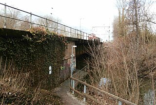
edit| Description |
Deutsch: Bahnbrücke über den Salinenkanal, mit sich näherndem Güterzug |
| Date | |
| Source | Own work |
| Author | Sarang |
| Other versions |
|

| Object location | | View this and other nearby images on: OpenStreetMap |
|---|
Licensing
edit
| I, the copyright holder of this work, release this work into the public domain. This applies worldwide. In some countries this may not be legally possible; if so: I grant anyone the right to use this work for any purpose, without any conditions, unless such conditions are required by law. |
File history
Click on a date/time to view the file as it appeared at that time.
| Date/Time | Thumbnail | Dimensions | User | Comment | |
|---|---|---|---|---|---|
| current | 10:52, 19 March 2021 | | 4,119 × 2,781 (727 KB) | Sarang (talk | contribs) | {{Information |Description= {{de|Bahnbrücke über den Salinenkanal, mit sich näherndem Güterzug}} |Date=2021-03-13 |Source={{own}} |Author={{U|Sarang}} |Other versions={{F|Beim 366 km langen Neckartalradweg, Brücke der Eisenbahn über die Kocher - panoramio.jpg|andere Sicht}} }} {{Object location|49°13′39.2″N 09°12′20.7″E|dim:320}} == {{int:license-header}} == {{PD-self}} B70 Category:Railway bridges in Landkreis Heilbronn [[Category:Bridges in Bad... |
You cannot overwrite this file.
File usage on Commons
The following 3 pages use this file: