File:Sally May (East) (32381434423).jpg
Original file (7,360 × 4,912 pixels, file size: 30.23 MB, MIME type: image/jpeg)
Captions
Captions
Summary
edit_(32381434423).jpg&action=edit§ion=1)
| Description |
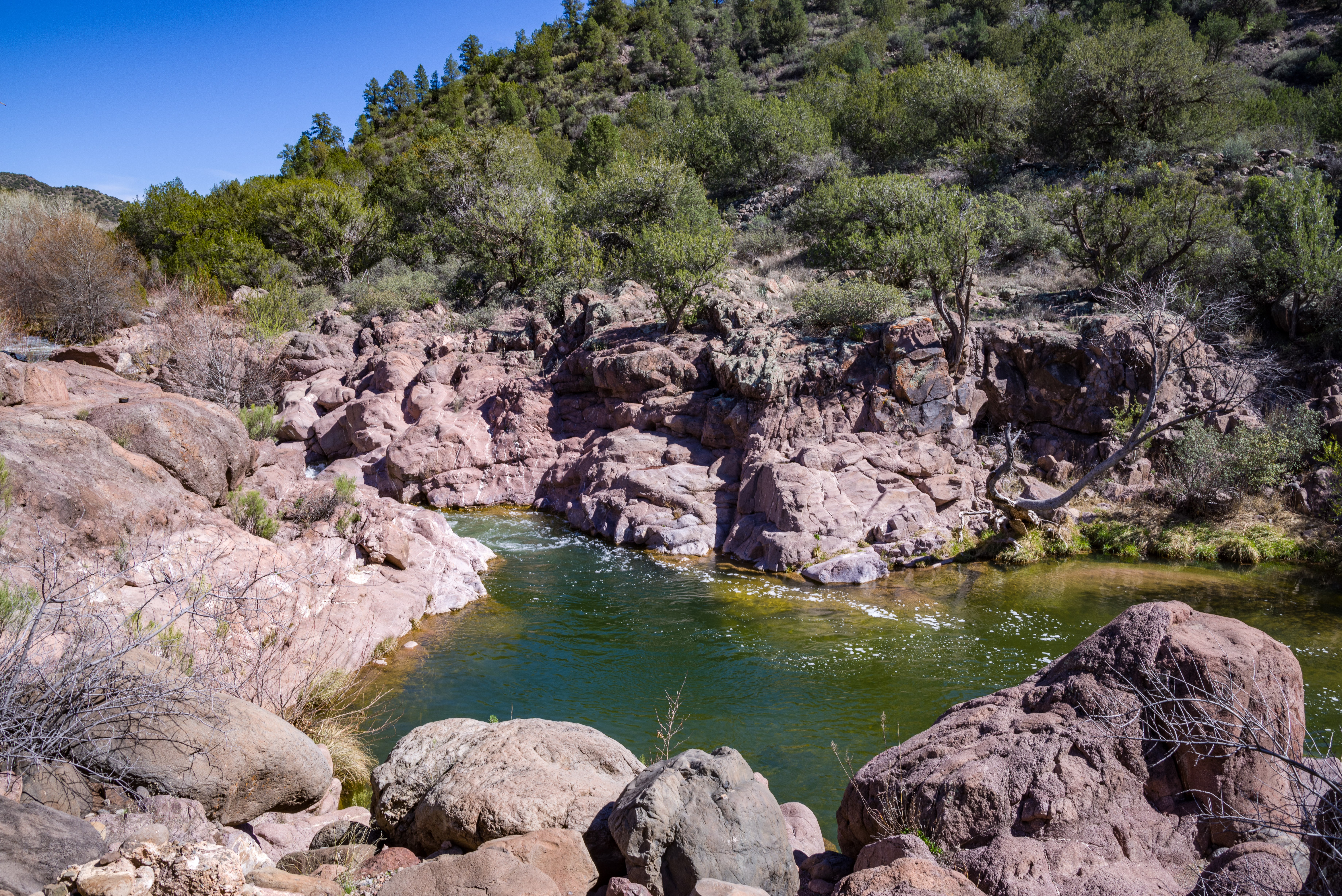
The Sally May site on Fossil Creek Wild and Scenic River offers some of the best swimming along the entire creek. There are two parking areas on either side of the bridge, which crosses Sally May Wash, on FR 502 (the Childs Power Road). Each lot has a path leading to separate pools along the creek. On the east (upstream) side of the bridge, the path leads to a large, deep pool at the base of a steep water feature. Rock shelves and cliff walls provide a lot of great spots for sunbathing and enjoying the canyon views. A smooth rock outcrop makes a great jumping-in spot. A small sandy beach at the far end of the pool offers shallow water entry and a good spot for smaller children to play. On the west (downstream) side of the bridge, there's a large open area above the parking lot that makes a great spot for a family picnic. The path to the creek leads to another swimming hole at the base of beautiful water feature. There are rocky banks to relax on, and a shallow sandy entry point not far downstream near a gravel-bottomed section of creek that is a great place to wade and splash. A bit of the creek's history remains along the banks here, structures from the days the Childs-Irving hydroelectric power plants used the creek to generate power for nearby mining communities like Jerome, Arizona. This photo was taken in early spring, just as trees were starting to bud. As the weather warms, the riparian area along Fossil Creek Wild and Scenic River becomes lush with thick greenery. Photo taken by Deborah Lee Soltesz, February 2017. Credit USFS Coconino National Forest. Learn more about visiting <a href="https://www.fs.usda.gov/recarea/coconino/recarea/?recid=75356" rel="nofollow">Fossil Creek Wild and Scenic River</a> managed by the <a href="https://www.fs.usda.gov/coconino/" rel="nofollow">Coconino National Forest</a>. |
| Date | |
| Source | Sally May (East) |
| Author | Coconino National Forest |
| Camera location | | View this and other nearby images on: OpenStreetMap |
|---|
_(32381434423).jpg¶ms=034.388020_N_-111.654850_E_globe:Earth_type:camera_source:Flickr_&language=en)
Licensing
edit_(32381434423).jpg&action=edit§ion=2)
| This image was originally posted to Flickr by Coconino National Forest at https://flickr.com/photos/42034606@N05/32381434423 (archive). It was reviewed on 8 September 2018 by FlickreviewR 2 and was confirmed to be licensed under the terms of the Public Domain Mark. |
This image or file is a work of a United States Department of Agriculture employee, taken or made as part of that person's official duties. As a work of the U.S. federal government, the image is in the public domain.
|
 |
File history
Click on a date/time to view the file as it appeared at that time.
| Date/Time | Thumbnail | Dimensions | User | Comment | |
|---|---|---|---|---|---|
| current | 06:16, 8 September 2018 | | 7,360 × 4,912 (30.23 MB) | Tyler ser Noche (talk | contribs) | Transferred from Flickr via #flickr2commons |
You cannot overwrite this file.
File usage on Commons
There are no pages that use this file.
_(32381434423).jpg&oldid=892460238)