File:Salt Creek (Haynes, Hocking County, Ohio, USA) 11 (38211791214).jpg

Original file (4,000 × 3,000 pixels, file size: 5.23 MB, MIME type: image/jpeg)
Captions
Captions
Summary edit
_11_(38211791214).jpg&action=edit§ion=1)
| Description |
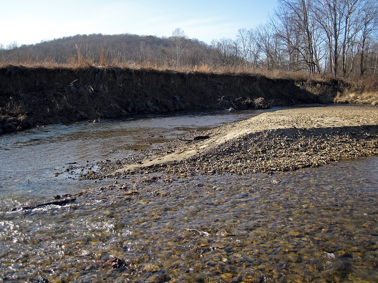
(upstream is to the right) Salt Creek is a significant tributary of the Scioto River east of Chillicothe in southern Ohio. At the site shown here (= Haynes, Ohio), Salt Creek generally flows southeast from the Laurelville area, for about 6 miles. The valley is relatively broad and is floored and rimmed by a mix of Quaternary-aged sand and gravel deposited in stream, lake, and glacial environments. Salt Creek Valley narrows downstream from here, which is unusual and unexpected. Normally, stream valleys generally widen the further downstream one proceeds. This is one of several lines of evidence indicating that Salt Creek used to run backward. Ancestral Salt Creek is called Laurelville Creek. It was a tributary to an ancient watercourse called the Groveport River (near Columbus), which itself was a tributary of the famous Teays River, the main drainage in pre-Ice Age Ohio. During an early ice advance in the Pleistocene Ice Age, a continental glacier blocked the Teays River. This caused flow reversal in many channels. Laurelville Creek's path was changed - it still flowed to the northwest from the site shown here, but it became a tributary of a new river - the Newark River. At this point in Salt Creek's history, it is known as Adelphi Creek. Later in the Pleistocene, the Illinoian Glaciation occurred and glacial ice reached the Haynes, Ohio area. Ice covered the valley and the surrounding uplands. At one stage, glacial ice just extended down Salt Creek Valley and terminated in the Haynes area. This blocked the northwestward-flow of Salt Creek and formed a glacial ice-dammed lake. Water overtopped the lake and caused erosion of a drainage divide to the south of here, resulting in overall southward flow. This continues to the present day, long after the ice-dammed lake disappeared. Locality: Salt Creek, a little west of Route 56 & north of Election Road, Haynes, southwestern Hocking County, southern Ohio, USA Mostly synthesized from: Hansen (1975) - Geology of the Hocking Hills State Park region. Ohio Division of Geological Survey Guidebook 4. 23 pp. (pdf available at: <a href="https://geosurvey.ohiodnr.gov/portals/geosurvey/PDFs/GuideBooks/GB_4.pdf" rel="nofollow">geosurvey.ohiodnr.gov/portals/geosurvey/PDFs/GuideBooks/G...</a>) (may take a little while to load - be patient) |
| Date | |
| Source | Salt Creek (Haynes, Hocking County, Ohio, USA) 11 |
| Author | James St. John |
Licensing edit
_11_(38211791214).jpg&action=edit§ion=2)
- You are free:
- to share – to copy, distribute and transmit the work
- to remix – to adapt the work
- Under the following conditions:
- attribution – You must give appropriate credit, provide a link to the license, and indicate if changes were made. You may do so in any reasonable manner, but not in any way that suggests the licensor endorses you or your use.
| This image was originally posted to Flickr by James St. John at https://flickr.com/photos/47445767@N05/38211791214 (archive). It was reviewed on 28 January 2020 by FlickreviewR 2 and was confirmed to be licensed under the terms of the cc-by-2.0. |
File history
Click on a date/time to view the file as it appeared at that time.
| Date/Time | Thumbnail | Dimensions | User | Comment | |
|---|---|---|---|---|---|
| current | 02:26, 28 January 2020 | | 4,000 × 3,000 (5.23 MB) | Ser Amantio di Nicolao (talk | contribs) | Transferred from Flickr via #flickr2commons |
You cannot overwrite this file.
File usage on Commons
There are no pages that use this file.
_11_(38211791214).jpg&oldid=710452116)