File:Salvation army world map.PNG

Original file (1,357 × 628 pixels, file size: 64 KB, MIME type: image/png)
Captions
Captions

|
This religion map image could be re-created using vector graphics as an SVG file. This has several advantages; see Commons:Media for cleanup for more information. If an SVG form of this image is available, please upload it and afterwards replace this template with
{{vector version available|new image name}}.
It is recommended to name the SVG file “Salvation army world map.svg”—then the template Vector version available (or Vva) does not need the new image name parameter. |
Summary
edit
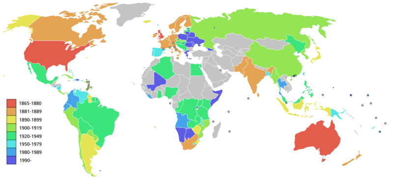
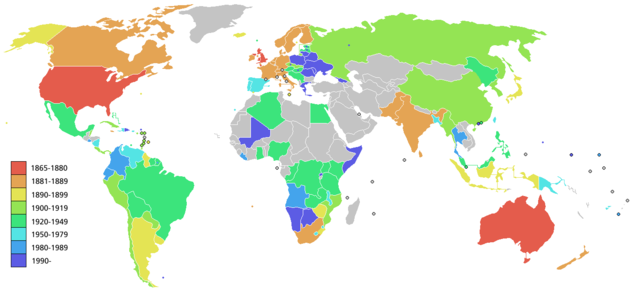
Map showing the Worldwide expansion of the Salvation Army as listed on w:Salvation Army (some areas shown are countries, other are regions). Since the map refers to locations over a 140 year period, some countries may not correspond exactly to the area of the original historic country where the Salvation army was originally founded in.
Note that countries where Salvation army recommenced are shown with a dot in the appropriate colour, while the whole country is shown in the colour of the original founding date.
Licensing
edit

|
Permission is granted to copy, distribute and/or modify this document under the terms of the GNU Free Documentation License, Version 1.2 or any later version published by the Free Software Foundation; with no Invariant Sections, no Front-Cover Texts, and no Back-Cover Texts. A copy of the license is included in the section entitled GNU Free Documentation License. |
| This file is licensed under the Creative Commons Attribution-Share Alike 3.0 Unported license. | ||
| ||
| This licensing tag was added to this file as part of the GFDL licensing update. |
File history
Click on a date/time to view the file as it appeared at that time.
| Date/Time | Thumbnail | Dimensions | User | Comment | |
|---|---|---|---|---|---|
| current | 11:28, 20 May 2008 | | 1,357 × 628 (64 KB) | Ictys~commonswiki (talk | contribs) | And Greec |
| 11:24, 20 May 2008 |  | 1,357 × 628 (64 KB) | Ictys~commonswiki (talk | contribs) | New version with Namibia and Mali | |
| 14:28, 26 February 2006 |  | 1,357 × 628 (37 KB) | Roke~commonswiki (talk | contribs) | Map showing the Worldwide expansion of the Salvation Army. Since the map refers to locations over a 140 year period, some countries may not correspond exactly to the area of the original historic country where the Salvation army was originally founded in. |
You cannot overwrite this file.
File usage on Commons
There are no pages that use this file.
File usage on other wikis
The following other wikis use this file:
- Usage on als.wikipedia.org
- Usage on de.wikipedia.org
- Usage on de.wikibooks.org
- Usage on en.wikipedia.org
- Usage on et.wikipedia.org
- Usage on fi.wikipedia.org
- Usage on gl.wikipedia.org
- Usage on hu.wikipedia.org
- Usage on id.wikipedia.org
- Usage on pl.wikipedia.org
- Usage on pt.wikipedia.org
- Usage on ro.wikipedia.org
- Usage on zh.wikipedia.org