File:Samuel Dunn, A new chart of the world (FL147409185 2725572).jpg
Size of this preview: 800 × 588 pixels. Other resolutions: 320 × 235 pixels | 640 × 470 pixels | 1,024 × 753 pixels | 1,280 × 941 pixels | 2,560 × 1,882 pixels | 3,360 × 2,470 pixels.
Original file (3,360 × 2,470 pixels, file size: 9.36 MB, MIME type: image/jpeg)
Captions
Captions
Add a one-line explanation of what this file represents
Summary
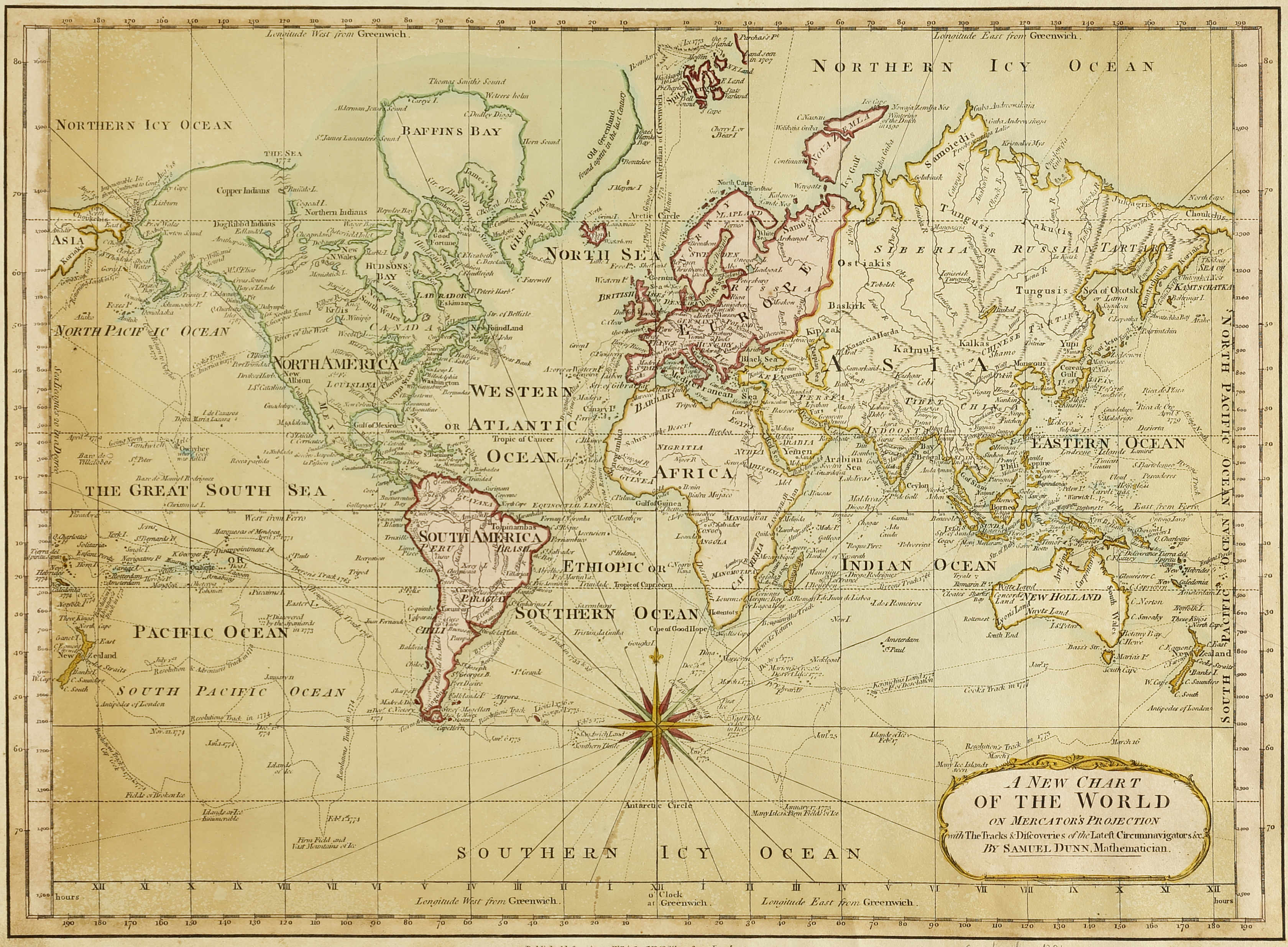
edit| Samuel Dunn: A new chart of the world
( |
||||||||||||||||||||||||
|---|---|---|---|---|---|---|---|---|---|---|---|---|---|---|---|---|---|---|---|---|---|---|---|---|
| Artist |
|
|||||||||||||||||||||||
| Title |
A new chart of the world |
|||||||||||||||||||||||
| Publisher |
Laurie and Whittle |
|||||||||||||||||||||||
| Description |
A new chart of the world. On Mercator's projection, with the tracks and discoveries of the latest circumnavigators . By Samuel Dunn. |
|||||||||||||||||||||||
| Language | English | |||||||||||||||||||||||
| Publication date | 1794 | |||||||||||||||||||||||
| Medium | 1 map : col ; | |||||||||||||||||||||||
| Dimensions | height: 30 cm (11.8 in); width: 41 cm (16.1 in) | |||||||||||||||||||||||
| Collection |
|
|||||||||||||||||||||||
| Current location |
|
|||||||||||||||||||||||
| Place of publication | London | |||||||||||||||||||||||
| search Merhav catalog | London | |||||||||||||||||||||||
| Notes | ||||||||||||||||||||||||
| IE PID | IE147409182 | |||||||||||||||||||||||
| Rosetta filename | FL147409185 | |||||||||||||||||||||||
| NNL item ID (P3959) | 990027255720205171 | |||||||||||||||||||||||
| search Merhav catalog | English, Samuel Dunn | |||||||||||||||||||||||
| search Merhav catalog | World mapsLaurie and Whittle | |||||||||||||||||||||||
| Source/Photographer |
|
|||||||||||||||||||||||
| Other versions | ||||||||||||||||||||||||
| Jpg / Tif version |
|
|||||||||||||||||||||||

.jpg)

.jpg&action=edit§ion=1)
Licensing
edit.jpg&action=edit§ion=2)
The copyright situation of this work is theoretically uncertain, because in the country of origin copyright lasts 70 years after the death of the author, and the date of the author's death is unknown. However, the date of creation of the work was over 120 years ago, and it is thus a reasonable assumption that the copyright has expired (see here for the community discussion). Do not use this template if the date of death of the author is known.
| |
| This file has been identified as being free of known restrictions under copyright law, including all related and neighboring rights. | |
File history
Click on a date/time to view the file as it appeared at that time.
| Date/Time | Thumbnail | Dimensions | User | Comment | |
|---|---|---|---|---|---|
| current | 23:38, 23 February 2024 | | 3,360 × 2,470 (9.36 MB) | Enyavar (talk | contribs) | Cropped 24 % horizontally, 19 % vertically, rotated -0.6° using CropTool with precise mode. |
| 15:50, 8 August 2023 |  | 4,425 × 3,043 (14.06 MB) | Geagea (talk | contribs) | pattypan 22.03 |
You cannot overwrite this file.
File usage on Commons
The following 2 pages use this file:
.jpg&oldid=855140402)