File:San Jose de Tumacacori (Mission, Ruins), Tubac, Santa Cruz County, AZ HABS ARIZ,12-TUBA.V,1- (sheet 8 of 11).png

Original file (14,456 × 9,632 pixels, file size: 4.51 MB, MIME type: image/png)
Captions
Captions
| This image is a JPEG version of the original TIF image at File: HABS ARIZ,12-TUBA.V,1- (sheet 8 of 11) - San Jose de Tumacacori (Mission, Ruins), Tubac, Santa Cruz County, AZ HABS ARIZ,12-TUBA.V,1- (sheet 8 of 11).tif.
However, any edits to the image should be based on the original TIF version in order to prevent generation loss, and both versions should be updated. Do not make edits based on this version. |
Summary edit
| Warning | The original file is very high-resolution. It might not load properly or could cause your browser to freeze when opened at full size. |
|---|
| HABS ARIZ,12-TUBA.V,1- (sheet 8 of 11) - San Jose de Tumacacori (Mission, Ruins), Tubac, Santa Cruz County, AZ | ||||
|---|---|---|---|---|
| Photographer |
Related names:
|
|||
| Title |
HABS ARIZ,12-TUBA.V,1- (sheet 8 of 11) - San Jose de Tumacacori (Mission, Ruins), Tubac, Santa Cruz County, AZ |
|||
| Depicted place | Arizona; Santa Cruz County; Tubac | |||
| Date | Documentation compiled after 1933 | |||
| Dimensions | 24 x 36 in. (D size) | |||
| Current location |
Library of Congress Prints and Photographs Division Washington, D.C. 20540 USA http://hdl.loc.gov/loc.pnp/pp.print |
|||
| Accession number |
HABS ARIZ,12-TUBA.V,1- (sheet 8 of 11) |
|||
| Credit line |
|
|||
| Notes |
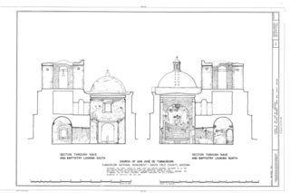
Santa Cruz County, Arizona, about 49 miles south of Tucson and 19 miles north of Hogales. It was created September 15, 1908. Upon the tract is located an ancient Spanish ruin, the Mission San Jose de Tumacacori, founded by the Jesuit priest, missionary, and explorer, Father Eusebio Francisco Kino, about 1691 The Sobaipuri Indians, who lived in the vicinity at that time, appear to have merged later with the Papago tribe.
|
|||
| Source | https://www.loc.gov/pictures/item/az0129.sheet.00041a | |||
| Permission (Reusing this file) |
|
|||
| Other versions |
,_Tubac,_Santa_Cruz_County,_AZ_HABS_ARIZ,12-TUBA.V,1-_(sheet_1_of_11).png) ,_Tubac,_Santa_Cruz_County,_AZ_HABS_ARIZ,12-TUBA.V,1-_(sheet_10_of_11).png) ,_Tubac,_Santa_Cruz_County,_AZ_HABS_ARIZ,12-TUBA.V,1-_(sheet_11_of_11).png) ,_Tubac,_Santa_Cruz_County,_AZ_HABS_ARIZ,12-TUBA.V,1-_(sheet_12_of_33).png) ,_Tubac,_Santa_Cruz_County,_AZ_HABS_ARIZ,12-TUBA.V,1-_(sheet_2_of_11).png) ,_Tubac,_Santa_Cruz_County,_AZ_HABS_ARIZ,12-TUBA.V,1-_(sheet_2_of_33).png) ,_Tubac,_Santa_Cruz_County,_AZ_HABS_ARIZ,12-TUBA.V,1-_(sheet_3_of_11).png) ,_Tubac,_Santa_Cruz_County,_AZ_HABS_ARIZ,12-TUBA.V,1-_(sheet_4_of_11).png) ,_Tubac,_Santa_Cruz_County,_AZ_HABS_ARIZ,12-TUBA.V,1-_(sheet_5_of_11).png) ,_Tubac,_Santa_Cruz_County,_AZ_HABS_ARIZ,12-TUBA.V,1-_(sheet_6_of_11).png) ,_Tubac,_Santa_Cruz_County,_AZ_HABS_ARIZ,12-TUBA.V,1-_(sheet_7_of_11).png) ,_Tubac,_Santa_Cruz_County,_AZ_HABS_ARIZ,12-TUBA.V,1-_(sheet_9_of_11).png) |
|||

,_Tubac,_Santa_Cruz_County,_AZ_HABS_ARIZ,12-TUBA.V,1-_(sheet_8_of_11).png&action=edit§ion=1)
| Camera location | | View this and other nearby images on: OpenStreetMap |
|---|
,_Tubac,_Santa_Cruz_County,_AZ_HABS_ARIZ,12-TUBA.V,1-_(sheet_8_of_11).png¶ms=031.612500_N_-111.045280_E_globe:Earth_type:camera__&language=en)
File history
Click on a date/time to view the file as it appeared at that time.
| Date/Time | Thumbnail | Dimensions | User | Comment | |
|---|---|---|---|---|---|
| current | 08:34, 30 June 2014 | | 14,456 × 9,632 (4.51 MB) | Fæ (talk | contribs) | {{Compressed version|file=File:HABS_ARIZ,12-TUBA.V,1-_(sheet_8_of_11)_-_San_Jose_de_Tumacacori_(Mission,_Ruins),_Tubac,_Santa_Cruz_County,_AZ_HABS_ARIZ,12-TUBA.V,1-_(sheet_8_of_11).tif|thumb=nothumb}} =={{int:filedesc}}== {{Photograph | accession num... |
You cannot overwrite this file.
File usage on Commons
The following 31 pages use this file:
- File:HABS ARIZ,12-TUBA.V,1- (sheet 8 of 11) - San Jose de Tumacacori (Mission, Ruins), Tubac, Santa Cruz County, AZ HABS ARIZ,12-TUBA.V,1- (sheet 8 of 11).png (file redirect)
- File:San Jose de Tumacacori (Mission, Ruins), Tubac, Santa Cruz County, AZ HABS ARIZ,12-TUBA.V,1- (sheet 10 of 11).png
- File:San Jose de Tumacacori (Mission, Ruins), Tubac, Santa Cruz County, AZ HABS ARIZ,12-TUBA.V,1- (sheet 10 of 11).tif
- File:San Jose de Tumacacori (Mission, Ruins), Tubac, Santa Cruz County, AZ HABS ARIZ,12-TUBA.V,1- (sheet 11 of 11).png
- File:San Jose de Tumacacori (Mission, Ruins), Tubac, Santa Cruz County, AZ HABS ARIZ,12-TUBA.V,1- (sheet 11 of 11).tif
- File:San Jose de Tumacacori (Mission, Ruins), Tubac, Santa Cruz County, AZ HABS ARIZ,12-TUBA.V,1- (sheet 12 of 33).png
- File:San Jose de Tumacacori (Mission, Ruins), Tubac, Santa Cruz County, AZ HABS ARIZ,12-TUBA.V,1- (sheet 12 of 33).tif
- File:San Jose de Tumacacori (Mission, Ruins), Tubac, Santa Cruz County, AZ HABS ARIZ,12-TUBA.V,1- (sheet 1 of 11).png
- File:San Jose de Tumacacori (Mission, Ruins), Tubac, Santa Cruz County, AZ HABS ARIZ,12-TUBA.V,1- (sheet 1 of 11).tif
- File:San Jose de Tumacacori (Mission, Ruins), Tubac, Santa Cruz County, AZ HABS ARIZ,12-TUBA.V,1- (sheet 2 of 11).png
- File:San Jose de Tumacacori (Mission, Ruins), Tubac, Santa Cruz County, AZ HABS ARIZ,12-TUBA.V,1- (sheet 2 of 11).tif
- File:San Jose de Tumacacori (Mission, Ruins), Tubac, Santa Cruz County, AZ HABS ARIZ,12-TUBA.V,1- (sheet 2 of 33).png
- File:San Jose de Tumacacori (Mission, Ruins), Tubac, Santa Cruz County, AZ HABS ARIZ,12-TUBA.V,1- (sheet 2 of 33).tif
- File:San Jose de Tumacacori (Mission, Ruins), Tubac, Santa Cruz County, AZ HABS ARIZ,12-TUBA.V,1- (sheet 30 of 33).tif
- File:San Jose de Tumacacori (Mission, Ruins), Tubac, Santa Cruz County, AZ HABS ARIZ,12-TUBA.V,1- (sheet 31 of 33).tif
- File:San Jose de Tumacacori (Mission, Ruins), Tubac, Santa Cruz County, AZ HABS ARIZ,12-TUBA.V,1- (sheet 32 of 33).tif
- File:San Jose de Tumacacori (Mission, Ruins), Tubac, Santa Cruz County, AZ HABS ARIZ,12-TUBA.V,1- (sheet 33 of 33).tif
- File:San Jose de Tumacacori (Mission, Ruins), Tubac, Santa Cruz County, AZ HABS ARIZ,12-TUBA.V,1- (sheet 3 of 11).png
- File:San Jose de Tumacacori (Mission, Ruins), Tubac, Santa Cruz County, AZ HABS ARIZ,12-TUBA.V,1- (sheet 3 of 11).tif
- File:San Jose de Tumacacori (Mission, Ruins), Tubac, Santa Cruz County, AZ HABS ARIZ,12-TUBA.V,1- (sheet 4 of 11).png
- File:San Jose de Tumacacori (Mission, Ruins), Tubac, Santa Cruz County, AZ HABS ARIZ,12-TUBA.V,1- (sheet 4 of 11).tif
- File:San Jose de Tumacacori (Mission, Ruins), Tubac, Santa Cruz County, AZ HABS ARIZ,12-TUBA.V,1- (sheet 5 of 11).png
- File:San Jose de Tumacacori (Mission, Ruins), Tubac, Santa Cruz County, AZ HABS ARIZ,12-TUBA.V,1- (sheet 5 of 11).tif
- File:San Jose de Tumacacori (Mission, Ruins), Tubac, Santa Cruz County, AZ HABS ARIZ,12-TUBA.V,1- (sheet 6 of 11).png
- File:San Jose de Tumacacori (Mission, Ruins), Tubac, Santa Cruz County, AZ HABS ARIZ,12-TUBA.V,1- (sheet 6 of 11).tif
- File:San Jose de Tumacacori (Mission, Ruins), Tubac, Santa Cruz County, AZ HABS ARIZ,12-TUBA.V,1- (sheet 7 of 11).png
- File:San Jose de Tumacacori (Mission, Ruins), Tubac, Santa Cruz County, AZ HABS ARIZ,12-TUBA.V,1- (sheet 7 of 11).tif
- File:San Jose de Tumacacori (Mission, Ruins), Tubac, Santa Cruz County, AZ HABS ARIZ,12-TUBA.V,1- (sheet 8 of 11).png
- File:San Jose de Tumacacori (Mission, Ruins), Tubac, Santa Cruz County, AZ HABS ARIZ,12-TUBA.V,1- (sheet 8 of 11).tif
- File:San Jose de Tumacacori (Mission, Ruins), Tubac, Santa Cruz County, AZ HABS ARIZ,12-TUBA.V,1- (sheet 9 of 11).png
- File:San Jose de Tumacacori (Mission, Ruins), Tubac, Santa Cruz County, AZ HABS ARIZ,12-TUBA.V,1- (sheet 9 of 11).tif
_-_San_Jose_de_Tumacacori_(Mission,_Ruins),_Tubac,_Santa_Cruz_County,_AZ_HABS_ARIZ,12-TUBA.V,1-_(sheet_8_of_11).png&redirect=no)
,_Tubac,_Santa_Cruz_County,_AZ_HABS_ARIZ,12-TUBA.V,1-_(sheet_8_of_11).png)
,_Tubac,_Santa_Cruz_County,_AZ_HABS_ARIZ,12-TUBA.V,1-_(sheet_8_of_11).png&oldid=664284534)