File:Sanba Sept 16 2012 0215Z.jpg

Size of this preview: 493 × 600 pixels. Other resolutions: 197 × 240 pixels | 394 × 480 pixels | 631 × 768 pixels | 842 × 1,024 pixels | 1,683 × 2,048 pixels | 6,740 × 8,200 pixels.
Original file (6,740 × 8,200 pixels, file size: 11.6 MB, MIME type: image/jpeg)
Captions
Captions
Add a one-line explanation of what this file represents
| Warning | The original file is very high-resolution. It might not load properly or could cause your browser to freeze when opened at full size. |
|---|
Summary
edit
| Camera location | | View this and other nearby images on: OpenStreetMap |
|---|
| Description |
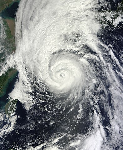
English: Typhoon Sanba over the Ryukyu Islands on September 16, 2012. |
| Date | |
| Source | http://rapidfire.sci.gsfc.nasa.gov/cgi-bin/imagery/single.cgi?image=Sanba.A2012260.0215.250m.jpg |
| Author | NASA |
Licensing
edit
| This file is in the public domain in the United States because it was solely created by NASA. NASA copyright policy states that "NASA material is not protected by copyright unless noted". (See Template:PD-USGov, NASA copyright policy page or JPL Image Use Policy.) | ||
 |
Warnings:
|
File history
Click on a date/time to view the file as it appeared at that time.
| Date/Time | Thumbnail | Dimensions | User | Comment | |
|---|---|---|---|---|---|
| current | 06:39, 23 August 2023 | | 6,740 × 8,200 (11.6 MB) | Nino Marakot (talk | contribs) | Reverted to version as of 17:20, 16 September 2012 (UTC) |
| 13:05, 17 November 2015 |  | 7,200 × 9,400 (8.74 MB) | Nino Marakot (talk | contribs) | better official version | |
| 17:20, 16 September 2012 |  | 6,740 × 8,200 (11.6 MB) | Meow (talk | contribs) | Official version. | |
| 05:29, 16 September 2012 |  | 6,120 × 6,760 (8.86 MB) | Meow (talk | contribs) | Fixed. | |
| 05:27, 16 September 2012 |  | 6,120 × 6,760 (8.59 MB) | Meow (talk | contribs) | User created page with UploadWizard |
You cannot overwrite this file.
File usage on Commons
The following page uses this file:
- File:Sanba 2012-09-16.jpg (file redirect)
File usage on other wikis
The following other wikis use this file:
- Usage on es.wikipedia.org
- Usage on ja.wikipedia.org
- Usage on zh.wikipedia.org