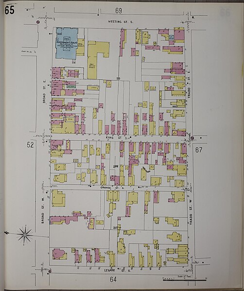
File:Sanborn Fire Insurance Map from Charleston, Charleston County, South Carolina, Volume 1, 1944, Plate 0065.jpg

Size of this preview: 502 × 599 pixels. Other resolutions: 201 × 240 pixels | 402 × 480 pixels | 643 × 768 pixels | 858 × 1,024 pixels | 1,716 × 2,048 pixels | 6,629 × 7,913 pixels.
Original file (6,629 × 7,913 pixels, file size: 3.65 MB, MIME type: image/jpeg)
Captions
Captions
Add a one-line explanation of what this file represents
Summary
edit
| Description |
English: Sanborn Fire Insurance Map from Charleston, Charleston County, South Carolina, Volume 1, 1944, Plate 0065 |
| Date | |
| Source | https://tile.loc.gov/image-services/iiif/service:gmd:gmd391m:g3914m:g3914cm:g3914cm_g08124194401:08124_01_1944-0065/full/pct:100/0/default.jpg |
| Author | Unknown author |
Licensing
edit
This work is in the public domain in the United States because it was published in the United States between 1929 and 1977, inclusive, without a copyright notice. For further explanation, see Commons:Hirtle chart as well as a detailed definition of "publication" for public art.
|
 |
File history
Click on a date/time to view the file as it appeared at that time.
| Date/Time | Thumbnail | Dimensions | User | Comment | |
|---|---|---|---|---|---|
| current | 19:18, 30 December 2023 | | 6,629 × 7,913 (3.65 MB) | Nowakki (talk | contribs) | == {{int:filedesc}} == {{Information |description={{en|1=Sanborn Fire Insurance Map from Charleston, Charleston County, South Carolina, Volume 1, 1944, Plate 0065}} |date=1944 |source=https://tile.loc.gov/image-services/iiif/service:gmd:gmd391m:g3914m:g3914cm:g3914cm_g08124194401:08124_01_1944-0065/full/pct:100/0/default.jpg |author={{Unknown|1=Author}} }} == {{int:license-header}} == {{PD-US-no notice}} [[Category:Sanborn Fire Insurance Map from Charleston, Charleston County, South Carolin... |
You cannot overwrite this file.
File usage on Commons
There are no pages that use this file.