File:Sandy and Beaver Canal map.jpg

Size of this preview: 560 × 600 pixels. Other resolutions: 224 × 240 pixels | 448 × 480 pixels | 717 × 768 pixels | 1,242 × 1,330 pixels.
Original file (1,242 × 1,330 pixels, file size: 319 KB, MIME type: image/jpeg)
Captions
Captions
Add a one-line explanation of what this file represents
Summary
edit
| Description |
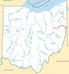
English: Approximate route of the Sandy and Beaver Canal (in red) in Ohio in the United States. A small portion of the western part of the canal acted as a feeder canal, bringing water into the Ohio and Erie Canal. The remainder of the canal was used to give inland agricultural producers access to the Ohio River. |
| Date | |
| Source | https://www.flickr.com/photos/timevanson/43484960904/ |
| Author | Tim Evanson |
| Other versions | Based on File:Major rivers and lakes of Ohio.jpg |
Licensing
edit
| This image was originally posted to Flickr by Tim Evanson at https://flickr.com/photos/23165290@N00/43484960904. It was reviewed on 22 August 2018 by FlickreviewR 2 and was confirmed to be licensed under the terms of the cc-by-sa-2.0. |
This file is licensed under the Creative Commons Attribution-Share Alike 2.0 Generic license.
- You are free:
- to share – to copy, distribute and transmit the work
- to remix – to adapt the work
- Under the following conditions:
- attribution – You must give appropriate credit, provide a link to the license, and indicate if changes were made. You may do so in any reasonable manner, but not in any way that suggests the licensor endorses you or your use.
- share alike – If you remix, transform, or build upon the material, you must distribute your contributions under the same or compatible license as the original.
File history
Click on a date/time to view the file as it appeared at that time.
| Date/Time | Thumbnail | Dimensions | User | Comment | |
|---|---|---|---|---|---|
| current | 19:11, 22 August 2018 | | 1,242 × 1,330 (319 KB) | Tim1965 (talk | contribs) | User created page with UploadWizard |
You cannot overwrite this file.
File usage on Commons
The following 3 pages use this file: