File:SatNordfriesischeInseln.jpg

Size of this preview: 296 × 600 pixels. Other resolutions: 118 × 240 pixels | 237 × 480 pixels | 379 × 768 pixels | 1,278 × 2,590 pixels.
Original file (1,278 × 2,590 pixels, file size: 1.63 MB, MIME type: image/jpeg)
Captions
Captions
Add a one-line explanation of what this file represents
Summary
edit
| Description |
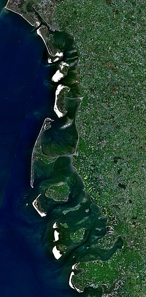
Deutsch: Satellitenaufnahme der Nordfriesischen Inseln (Dänemark/Deutschland) |
| Date | 21 December 2005 (upload date) |
| Source | Satellite imagery taken from NASA World Wind software (by screenshot) |
| Author | NASA |
Licensing
edit
| This image is in the public domain because it is a screenshot from NASA’s globe software World Wind using a public domain layer, such as Blue Marble, MODIS, Landsat, SRTM, USGS or GLOBE.
|
 |
File history
Click on a date/time to view the file as it appeared at that time.
| Date/Time | Thumbnail | Dimensions | User | Comment | |
|---|---|---|---|---|---|
| current | 18:37, 21 December 2005 | | 1,278 × 2,590 (1.63 MB) | Godewind (talk | contribs) | * Satellitenaufnahme Nordfriesischen Inseln (Dänemark/Deutschland) * from Nasa World Wind - Free Satellite Image {{PD-USGov}} Category:Satellite photos Category:Satellite images of the islands |
You cannot overwrite this file.
File usage on Commons
There are no pages that use this file.
File usage on other wikis
The following other wikis use this file:
- Usage on br.wikipedia.org
- Usage on cs.wikipedia.org
- Usage on de.wikipedia.org
- Usage on el.wikipedia.org
- Usage on es.wikipedia.org
- Usage on frr.wikipedia.org
- Usage on hu.wikipedia.org
- Usage on pl.wikipedia.org
- Usage on stq.wikipedia.org
- Usage on zh.wikipedia.org