File:Satellite Image of Ozone Hole in 2007.jpg

Size of this preview: 600 × 600 pixels. Other resolutions: 240 × 240 pixels | 480 × 480 pixels | 700 × 700 pixels.
Original file (700 × 700 pixels, file size: 216 KB, MIME type: image/jpeg)
Captions
Captions
Add a one-line explanation of what this file represents
Summary
edit
| Description |
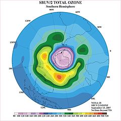
English: Ozone analysis map showing "ozone hole" over Antarctic continent. Data obtained from a Solar Backscatter Ultraviolet (SBUV/2) instrument on board the NOAA-18 weather satellite. |
| Date | |
| Source | http://www.photolib.noaa.gov/htmls/spac0539.htm |
| Author | National Oceanic & Atmospheric Administration (NOAA) |
NOAA In Space Collection, image ID: spac0539
Licensing
edit
This image is in the public domain because it contains materials that originally came from the U.S. National Oceanic and Atmospheric Administration, taken or made as part of an employee's official duties.
|
File history
Click on a date/time to view the file as it appeared at that time.
| Date/Time | Thumbnail | Dimensions | User | Comment | |
|---|---|---|---|---|---|
| current | 20:30, 13 June 2015 | | 700 × 700 (216 KB) | WhiteBook (talk | contribs) | User created page with UploadWizard |
You cannot overwrite this file.
File usage on Commons
There are no pages that use this file.