File:Satellite Sees An Atlantic Triple Tropical Threat - Flickr - NASA Goddard Photo and Video.jpg

Original file (3,072 × 3,072 pixels, file size: 1.33 MB, MIME type: image/jpeg)
Captions
Captions
Summary edit
| Description |
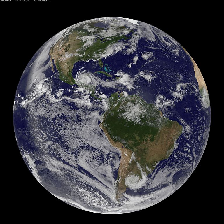
Image acquired August 8, 2012 There are three storms in the Atlantic Ocean basin on August 8, 2012 that have caught forecasters attention at the National Hurricane Center and they were captured in one image from NOAA's GOES-13 satellite. To the west lies Tropical Storm Ernesto, currently moving over Mexico. At 11:15 p.m. EDT on Tuesday, August 7, Belize radar indicated Ernesto made landfall along the southern Yucatan coast near Mahahual, Mexico as a category one hurricane with maximum sustained winds near 85 mph (140 kmh). At 10 a.m. EDT on August 8, Ernesto's maximum sustained winds were near 50 mph (85 kmh) and it was 265 miles (425 km) east of Coatzacoalcos, Mexico, near 18.7 North and 90.4 West. The National Hurricane Center expects Ernesto's center to emerge into the extreme southern Bay Of Campeche tonight where it is expected to re-strengthen. The second area forecasters are eyeing is that of post-tropical storm Florence's remains, located about 450 miles east of the Northern Leeward Islands. The remnants are still producing thunderstorms and showers, although it remains disorganized. The National Hurricane Center gives that low pressure area a "near zero" chance of becoming a tropical depression over the next couple of days. Farthest east lies a low pressure area associated with a tropical wave in the eastern Atlantic. It is about 700 miles west-southwest of the Cape Verde Islands and has a 30 percent chance of becoming a tropical depression in the next two days, according to the National Hurricane Center. Rob Gutro, NASA Goddard Space Flight Center NASA Goddard Space Flight Center enables NASA’s mission through four scientific endeavors: Earth Science, Heliophysics, Solar System Exploration, and Astrophysics. Goddard plays a leading role in NASA’s accomplishments by contributing compelling scientific knowledge to advance the Agency’s mission. Follow us on Twitter Like us on Facebook Find us on Instagram |
| Date | |
| Source | Satellite Sees An Atlantic Triple Tropical Threat |
| Author | NASA Goddard Space Flight Center from Greenbelt, MD, USA |
Licensing edit
- You are free:
- to share – to copy, distribute and transmit the work
- to remix – to adapt the work
- Under the following conditions:
- attribution – You must give appropriate credit, provide a link to the license, and indicate if changes were made. You may do so in any reasonable manner, but not in any way that suggests the licensor endorses you or your use.
| This image was originally posted to Flickr by NASA Goddard Photo and Video at https://www.flickr.com/photos/24662369@N07/7741851934. It was reviewed on 17 August 2012 by FlickreviewR and was confirmed to be licensed under the terms of the cc-by-2.0. |
| This file is in the public domain in the United States because it was solely created by NASA. NASA copyright policy states that "NASA material is not protected by copyright unless noted". (See Template:PD-USGov, NASA copyright policy page or JPL Image Use Policy.) | ||
 |
Warnings:
|
File history
Click on a date/time to view the file as it appeared at that time.
| Date/Time | Thumbnail | Dimensions | User | Comment | |
|---|---|---|---|---|---|
| current | 19:42, 17 August 2012 | | 3,072 × 3,072 (1.33 MB) | Werieth (talk | contribs) | == {{int:filedesc}} == {{Information |Description=Image acquired August 8, 2012 There are three storms in the Atlantic Ocean basin on August 8, 2012 that have caught forecasters attention at the National Hurricane Center and they were captured in one ... |
You cannot overwrite this file.
File usage on Commons
The following 3 pages use this file:
File usage on other wikis
The following other wikis use this file:
- Usage on uk.wikipedia.org