File:Satellite image of La Soufrière volcanic ash, 2021.jpg

Size of this preview: 800 × 360 pixels. Other resolutions: 320 × 144 pixels | 640 × 288 pixels | 1,024 × 461 pixels | 1,280 × 576 pixels | 2,560 × 1,152 pixels | 5,041 × 2,269 pixels.
Original file (5,041 × 2,269 pixels, file size: 1.09 MB, MIME type: image/jpeg)
Captions
Captions
Add a one-line explanation of what this file represents
Summary
edit
| Description |
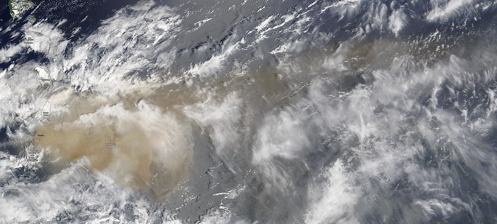
English: Satellite image of the La Soufrière volcano during the 2020-2021 eruptions, showing volcanic ash spreading to the islands of Saint Vincent, Barbados, and over the Atlantic ocean.
Português: Imagem de satélite do vulcão La Soufrière durante as erupções de 2020-2021, mostrando cinzas vulcânicas se espalhando para as ilhas de São Vicente, Barbados, e sobre o oceano Atlântico. |
| Date | |
| Source | https://worldview.earthdata.nasa.gov/?v=-69.09228124281717,8.322165532992722,-47.675659498598485,18.818541085758234&l=Reference_Labels,Reference_Features,Coastlines(hidden),MODIS_Terra_CorrectedReflectance_TrueColor&lg=false&t=2021-04-10-T17%3A46%3A53Z |
| Author | Terra / MODIS (coastlines and names: OpenStreetMap contributors) |
Licensing
edit
| This file is in the public domain in the United States because it was solely created by NASA. NASA copyright policy states that "NASA material is not protected by copyright unless noted". (See Template:PD-USGov, NASA copyright policy page or JPL Image Use Policy.) | ||
 |
Warnings:
|
File history
Click on a date/time to view the file as it appeared at that time.
| Date/Time | Thumbnail | Dimensions | User | Comment | |
|---|---|---|---|---|---|
| current | 19:21, 10 April 2021 | | 5,041 × 2,269 (1.09 MB) | Themium (talk | contribs) | Uploaded a work by Terra / MODIS (coastlines and names: OpenStreetMap contributors) from https://worldview.earthdata.nasa.gov/?v=-69.09228124281717,8.322165532992722,-47.675659498598485,18.818541085758234&l=Reference_Labels,Reference_Features,Coastlines(hidden),MODIS_Terra_CorrectedReflectance_TrueColor&lg=false&t=2021-04-10-T17%3A46%3A53Z with UploadWizard |
You cannot overwrite this file.
File usage on Commons
There are no pages that use this file.