File:Saxenegg-1030841-Hinweistafel-Burgruine-Planskizze.jpg

Size of this preview: 429 × 599 pixels. Other resolutions: 172 × 240 pixels | 344 × 480 pixels | 550 × 768 pixels | 733 × 1,024 pixels | 1,852 × 2,586 pixels.
Original file (1,852 × 2,586 pixels, file size: 427 KB, MIME type: image/jpeg)
Captions
Captions
Add a one-line explanation of what this file represents
Summary
edit
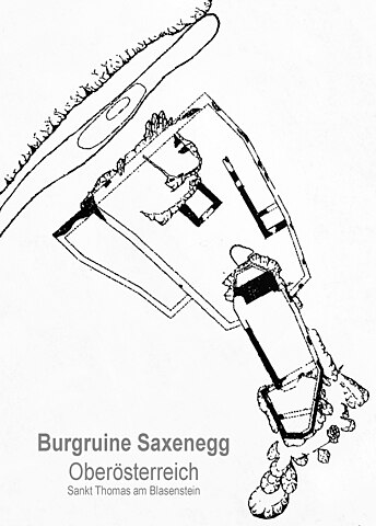
| Description | Burgruine Saxenegg im Saxenegger Wald in der Gemeinde Sankt Thomas am Blasenstein (andere Schreibweise St. Thomas am Blasenstein, St. Thomas a. Bl.) in Oberösterreich (Austria). Foto Jänner 2021. Öffentliche Hinweistafel der Wanderregion Strudengau. Standort Burgruine. Detail mit genordeter Planskizze. |
| Date | |
| Source | Foto |
| Author | TREM-RRRR |
Licensing
edit
I, the copyright holder of this work, hereby publish it under the following license:
| This file is made available under the Creative Commons CC0 1.0 Universal Public Domain Dedication. | |
| The person who associated a work with this deed has dedicated the work to the public domain by waiving all of their rights to the work worldwide under copyright law, including all related and neighboring rights, to the extent allowed by law. You can copy, modify, distribute and perform the work, even for commercial purposes, all without asking permission.
|
File history
Click on a date/time to view the file as it appeared at that time.
| Date/Time | Thumbnail | Dimensions | User | Comment | |
|---|---|---|---|---|---|
| current | 11:47, 11 January 2021 | | 1,852 × 2,586 (427 KB) | TREM-RRRR (talk | contribs) | {{Information |Description=Burgruine Saxenegg im Saxenegger Wald in der Gemeinde Sankt Thomas am Blasenstein (andere Schreibweise St. Thomas am Blasenstein, St. Thomas a. Bl.) in Oberösterreich (Austria). Foto Jänner 2021. Öffentliche Hinweistafel der Wanderregion Strudengau. Standort Burgruine. Detail mit Planskizze. |Source=Foto |Date=2021 |Author=TREM-RRRR |Permission= |other_versions= }} Category:Burgruine Saxenegg Category:Sankt Thomas am Blasenstein |
You cannot overwrite this file.
File usage on Commons
The following page uses this file:
File usage on other wikis
The following other wikis use this file:
- Usage on de.wikipedia.org