File:Schlesien-3Bezirke.png

Size of this preview: 644 × 600 pixels. Other resolutions: 258 × 240 pixels | 515 × 480 pixels | 825 × 768 pixels | 1,099 × 1,024 pixels | 2,000 × 1,863 pixels.
Original file (2,000 × 1,863 pixels, file size: 207 KB, MIME type: image/png)
Captions
Captions
Add a one-line explanation of what this file represents
Summary
edit
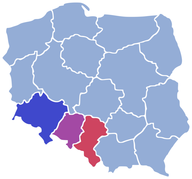
"* Beschreibung: Schlesiens heutige polnische Wojwodschaften (Breslau, Oppeln und Kattowitz) * Quelle: 1 der Wikipedia-Karten Polens mit Bezirksgrenzen
- gezeichnet: Benutzer:Geof, 20. September 2004
- Andere Versionen: z. B.
- Lizenzstatus: GNU FDL"
Licensing
edit

|
Permission is granted to copy, distribute and/or modify this document under the terms of the GNU Free Documentation License, Version 1.2 or any later version published by the Free Software Foundation; with no Invariant Sections, no Front-Cover Texts, and no Back-Cover Texts. A copy of the license is included in the section entitled GNU Free Documentation License. |
| This file is licensed under the Creative Commons Attribution-Share Alike 3.0 Unported license. | ||
| ||
| This licensing tag was added to this file as part of the GFDL licensing update. |
File history
Click on a date/time to view the file as it appeared at that time.
| Date/Time | Thumbnail | Dimensions | User | Comment | |
|---|---|---|---|---|---|
| current | 09:49, 12 August 2020 | | 2,000 × 1,863 (207 KB) | Andrew J.Kurbiko (talk | contribs) | https://commons.wikimedia.org/wiki/File:POL_location_map.svg |
| 15:13, 7 May 2007 |  | 200 × 200 (35 KB) | PetrusSilesius (talk | contribs) | Auf eine alte Version zurückgesetzt | |
| 19:19, 9 April 2007 |  | 200 × 200 (35 KB) | LUCPOL (talk | contribs) | Reverted to earlier revision | |
| 16:41, 31 March 2007 |  | 200 × 200 (35 KB) | PetrusSilesius (talk | contribs) | Auf eine alte Version zurückgesetzt | |
| 13:24, 10 March 2007 |  | 200 × 200 (35 KB) | LUCPOL (talk | contribs) | ||
| 12:36, 26 October 2006 |  | 200 × 200 (35 KB) | Nowis (talk | contribs) | "* Beschreibung: Schlesiens heutige polnische Wojwodschaften (Breslau, Oppeln und Kattowitz) * Quelle: 1 der Wikipedia-Karten Polens mit Bezirksgrenzen * gezeichnet: Benutzer:Geof, 20. September 2004 * Andere Versionen: z. B. * Lizenzstatus: GNU FDL" |
You cannot overwrite this file.
File usage on Commons
There are no pages that use this file.
File usage on other wikis
The following other wikis use this file:
- Usage on af.wikipedia.org
- Usage on de.wikipedia.org
- Usage on el.wikipedia.org
- Usage on ja.wikipedia.org
- Usage on lb.wikipedia.org