File:Schloss Inzing.PNG
No higher resolution available.
Schloss_Inzing.PNG (593 × 287 pixels, file size: 456 KB, MIME type: image/png)
Captions
Captions
Add a one-line explanation of what this file represents
Summary
edit
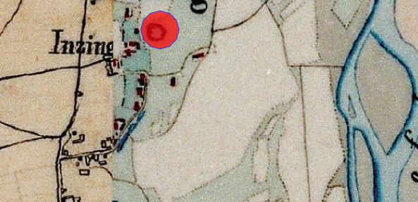
| Description | Lageplan des Schlosses Inzing auf dem Urkataster von Bayern |
| Date | circa 1830 |
| Source | Geobasisdaten: Bayerische Vermessungsverwaltung |
| Author | Königreich Bayern |
| Permission (Reusing this file) |
CC BY-ND 3.0 DE |
Licensing
edit
|
This work is in the public domain in its country of origin and other countries and areas where the copyright term is the author's life plus 70 years or fewer. | |
| This file has been identified as being free of known restrictions under copyright law, including all related and neighboring rights. | |
File history
Click on a date/time to view the file as it appeared at that time.
| Date/Time | Thumbnail | Dimensions | User | Comment | |
|---|---|---|---|---|---|
| current | 08:00, 3 September 2021 | | 593 × 287 (456 KB) | Luckyprof (talk | contribs) | {{Information |Description=Lageplan des Schlosses Inzing auf dem Urkataster von Bayern |Source=Geobasisdaten: Bayerische Vermessungsverwaltung |Date=3twa 1830 |Author=Königreich Bayern |Permission=CC BY-ND 3.0 DE |other_versions= }} Category:Districts of Pocking Category:Inzing (Pocking) |
You cannot overwrite this file.
File usage on Commons
There are no pages that use this file.
File usage on other wikis
The following other wikis use this file:
- Usage on de.wikipedia.org